

België
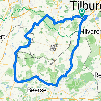
Ronde België 1 - Goirle - Lier
A cycling route starting in Goirle, North Brabant, The Netherlands.
Overview
About this route
- -:--
- Duration
- 81.2 km
- Distance
- 241 m
- Ascent
- 249 m
- Descent
- ---
- Avg. speed
- 36 m
- Max. altitude

Part of
België
12 stages
Route quality
Waytypes & surfaces along the route
Waytypes
Cycleway
47.9 km
(59 %)
Quiet road
23.6 km
(29 %)
Surfaces
Paved
57.7 km
(71 %)
Unpaved
8.1 km
(10 %)
Asphalt
50.4 km
(62 %)
Gravel
5.7 km
(7 %)
Continue with Bikemap
Use, edit, or download this cycling route
You would like to ride Ronde België 1 - Goirle - Lier or customize it for your own trip? Here is what you can do with this Bikemap route:
Free features
- Save this route as favorite or in collections
- Copy & plan your own version of this route
- Split it into stages to create a multi-day tour
- Sync your route with Garmin or Wahoo
Premium features
Free trial for 3 days, or one-time payment. More about Bikemap Premium.
- Navigate this route on iOS & Android
- Export a GPX / KML file of this route
- Create your custom printout (try it for free)
- Download this route for offline navigation
Discover more Premium features.
Get Bikemap PremiumFrom our community
Other popular routes starting in Goirle
 MTB Toertocht Goirle 2010
- Distance
- 55.2 km
- Ascent
- 70 m
- Descent
- 70 m
- Location
- Goirle, North Brabant, The Netherlands
 Route A
- Distance
- 65.4 km
- Ascent
- 62 m
- Descent
- 60 m
- Location
- Goirle, North Brabant, The Netherlands
 Goirle Reusel Poppel Goirle
- Distance
- 54.1 km
- Ascent
- 65 m
- Descent
- 65 m
- Location
- Goirle, North Brabant, The Netherlands
 ZO 80 - Goirle - Hilvarenbeek - Baarschot - Vessem - Knegsel - Duizel - Hoogeloon - Casteren - Hulsel - Hooge Mierde - Poppel - Goirle
- Distance
- 79.8 km
- Ascent
- 58 m
- Descent
- 60 m
- Location
- Goirle, North Brabant, The Netherlands
 MTB de Hellen
- Distance
- 61.2 km
- Ascent
- 80 m
- Descent
- 80 m
- Location
- Goirle, North Brabant, The Netherlands
 NO 85 - Goirle - Moergestel - Oisterwijk - Haaren - Esch - St. Michielsgestel - Gemonde - Olland - Liempde - Mortelen - Spoordonk - Kanaal - Haghorst - Goirle
- Distance
- 86.2 km
- Ascent
- 66 m
- Descent
- 66 m
- Location
- Goirle, North Brabant, The Netherlands
 3-Uurs trainingsronde
- Distance
- 87 km
- Ascent
- 43 m
- Descent
- 44 m
- Location
- Goirle, North Brabant, The Netherlands
 Pondjes route
- Distance
- 64.5 km
- Ascent
- 53 m
- Descent
- 56 m
- Location
- Goirle, North Brabant, The Netherlands
Open it in the app