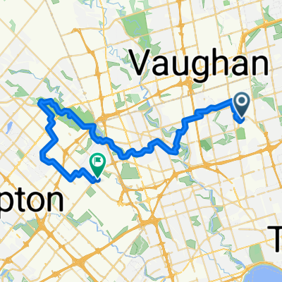
bike route from 2757 to Kipling subway station
A cycling route starting in Concord, Ontario, Canada.
Overview
About this route
I did not official ride on this route. However what I did yesterday I chose to bike ride for 15 minites to my nearest grocery store on a busy hour to see how accessible or accomodating it it for bikers. to my oberservation the ride was really scarry and intense because i was riding the bike with pedestrian and cars. most times i really had to slow down because pedestrians used the bike lane to walk on. i was also sharing the road with mothers pushing they babies in strollers and people with accible needs. the other issue that happened was when to cross the road, even if it was my turn or right of way it was difficult for drivers to observe that, that most i hand signal them to go and then i proceeded with my ride.
- -:--
- Duration
- 16.1 km
- Distance
- 84 m
- Ascent
- 116 m
- Descent
- ---
- Avg. speed
- 167 m
- Avg. speed
Route quality
Waytypes & surfaces along the route
Waytypes
Quiet road
7.7 km
(48 %)
Busy road
3.5 km
(22 %)
Surfaces
Paved
14.5 km
(90 %)
Asphalt
13.2 km
(82 %)
Concrete
1.3 km
(8 %)
Undefined
1.6 km
(10 %)
Continue with Bikemap
Use, edit, or download this cycling route
You would like to ride bike route from 2757 to Kipling subway station or customize it for your own trip? Here is what you can do with this Bikemap route:
Free features
- Save this route as favorite or in collections
- Copy & plan your own version of this route
- Sync your route with Garmin or Wahoo
Premium features
Free trial for 3 days, or one-time payment. More about Bikemap Premium.
- Navigate this route on iOS & Android
- Export a GPX / KML file of this route
- Create your custom printout (try it for free)
- Download this route for offline navigation
Discover more Premium features.
Get Bikemap PremiumFrom our community
Other popular routes starting in Concord
- humber river
- Distance
- 37.1 km
- Ascent
- 397 m
- Descent
- 455 m
- Location
- Concord, Ontario, Canada
- Pioneer Village to Union Station Via Humber River and Martin Goodman Trails
- Distance
- 45.4 km
- Ascent
- 281 m
- Descent
- 393 m
- Location
- Concord, Ontario, Canada
- kcc100
- Distance
- 105.2 km
- Ascent
- 345 m
- Descent
- 343 m
- Location
- Concord, Ontario, Canada
- Vaughan station to Kortright conservation park
- Distance
- 31.1 km
- Ascent
- 475 m
- Descent
- 475 m
- Location
- Concord, Ontario, Canada
- Downsview Park to High Park Zoo Via West Humber and Centennial Park
- Distance
- 49.5 km
- Ascent
- 303 m
- Descent
- 384 m
- Location
- Concord, Ontario, Canada
- Humber Recreational Trail
- Distance
- 24.5 km
- Ascent
- 73 m
- Descent
- 143 m
- Location
- Concord, Ontario, Canada
- Lake Wilcox Vishnu Mandir
- Distance
- 64.3 km
- Ascent
- 430 m
- Descent
- 432 m
- Location
- Concord, Ontario, Canada
- Downsview Park to Malton Via West Humber and Claireville Ranch
- Distance
- 45.3 km
- Ascent
- 255 m
- Descent
- 279 m
- Location
- Concord, Ontario, Canada
Open it in the app