
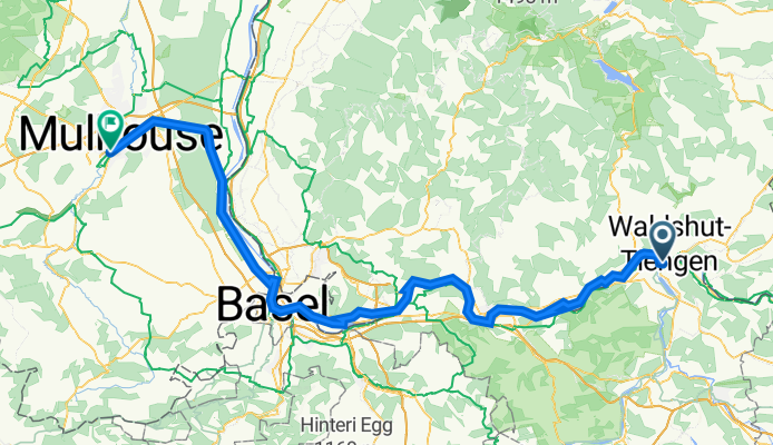
2_Waldshut bis Mulhouse
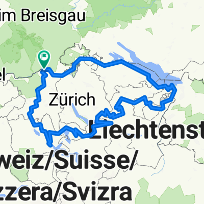
A cycling route starting in Koblenz, Canton of Aargau, Switzerland.
Overview
About this route
Half France Tour from Constance. Stage two: Camping Waldshut to Camping Mulhouse.
- -:--
- Duration
- 108.2 km
- Distance
- 368 m
- Ascent
- 440 m
- Descent
- ---
- Avg. speed
- 330 m
- Max. altitude

Route quality
Waytypes & surfaces along the route
Waytypes
Quiet road
28.1 km
(26 %)
Cycleway
28.1 km
(26 %)
Surfaces
Paved
81.1 km
(75 %)
Unpaved
22.7 km
(21 %)
Asphalt
80.1 km
(74 %)
Gravel
17.3 km
(16 %)
Continue with Bikemap
Use, edit, or download this cycling route
You would like to ride 2_Waldshut bis Mulhouse or customize it for your own trip? Here is what you can do with this Bikemap route:
Free features
- Save this route as favorite or in collections
- Copy & plan your own version of this route
- Split it into stages to create a multi-day tour
- Sync your route with Garmin or Wahoo
Premium features
Free trial for 3 days, or one-time payment. More about Bikemap Premium.
- Navigate this route on iOS & Android
- Export a GPX / KML file of this route
- Create your custom printout (try it for free)
- Download this route for offline navigation
Discover more Premium features.
Get Bikemap PremiumFrom our community
Other popular routes starting in Koblenz
 2_Waldshut bis Mulhouse
- Distance
- 108.2 km
- Ascent
- 368 m
- Descent
- 440 m
- Location
- Koblenz, Canton of Aargau, Switzerland
 Hausberg Maxi
- Distance
- 48.2 km
- Ascent
- 1,044 m
- Descent
- 1,041 m
- Location
- Koblenz, Canton of Aargau, Switzerland
 teil4 mit herzenroute 580km
- Distance
- 576.4 km
- Ascent
- 9,803 m
- Descent
- 9,803 m
- Location
- Koblenz, Canton of Aargau, Switzerland
 Waldshut - Lörrach
- Distance
- 68.4 km
- Ascent
- 194 m
- Descent
- 166 m
- Location
- Koblenz, Canton of Aargau, Switzerland
 Bodenseeumfahrung
- Distance
- 312.7 km
- Ascent
- 538 m
- Descent
- 538 m
- Location
- Koblenz, Canton of Aargau, Switzerland
 Koblenz nach Trasadingen
- Distance
- 22.1 km
- Ascent
- 103 m
- Descent
- 12 m
- Location
- Koblenz, Canton of Aargau, Switzerland
 Rhein 2019 2. Etappe
- Distance
- 59.9 km
- Ascent
- 199 m
- Descent
- 262 m
- Location
- Koblenz, Canton of Aargau, Switzerland
 1. Koblenz - Bad Säckingen (27 km)
- Distance
- 26.7 km
- Ascent
- 155 m
- Descent
- 149 m
- Location
- Koblenz, Canton of Aargau, Switzerland
Open it in the app