

TH-Hainich ab Craula
A cycling route starting in Weberstedt, Thuringia, Germany.
Overview
About this route
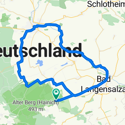
<p>Hiking route through Hainich with a view of Wartburg.</p>
<p>Rest areas after 3 km, 7.5 km (Silberborn), 8.5 km (Malinde hiking parking), 10.5 km, 12 km</p>
Translated, show original (German)- -:--
- Duration
- 16.9 km
- Distance
- 350 m
- Ascent
- 350 m
- Descent
- ---
- Avg. speed
- 497 m
- Max. altitude

Continue with Bikemap
Use, edit, or download this cycling route
You would like to ride TH-Hainich ab Craula or customize it for your own trip? Here is what you can do with this Bikemap route:
Free features
- Save this route as favorite or in collections
- Copy & plan your own version of this route
- Sync your route with Garmin or Wahoo
Premium features
Free trial for 3 days, or one-time payment. More about Bikemap Premium.
- Navigate this route on iOS & Android
- Export a GPX / KML file of this route
- Create your custom printout (try it for free)
- Download this route for offline navigation
Discover more Premium features.
Get Bikemap PremiumFrom our community
Other popular routes starting in Weberstedt
 Thiemsburg-Bad Langensalza-Stadtbesuch
- Distance
- 21 km
- Ascent
- 579 m
- Descent
- 581 m
- Location
- Weberstedt, Thuringia, Germany
 Hainich-Bad Langensalza-Unstrut
- Distance
- 64.6 km
- Ascent
- 0 m
- Descent
- 344 m
- Location
- Weberstedt, Thuringia, Germany
 TH-Hainich ab Craula
- Distance
- 16.9 km
- Ascent
- 350 m
- Descent
- 350 m
- Location
- Weberstedt, Thuringia, Germany
 Tour durch den Nationalpark Hainich mit Start + Ziel Campingplatz Weberstedt
- Distance
- 24.2 km
- Ascent
- 335 m
- Descent
- 335 m
- Location
- Weberstedt, Thuringia, Germany
 2015 Nationalpark Hanisch Zimmern,Grumbach,Craula
- Distance
- 28.6 km
- Ascent
- 343 m
- Descent
- 338 m
- Location
- Weberstedt, Thuringia, Germany
 Thiemsburg-Eisenach: Version 3
- Distance
- 62.5 km
- Ascent
- 0 m
- Descent
- 343 m
- Location
- Weberstedt, Thuringia, Germany
 2015 Nationalpark Hainisch
- Distance
- 58.2 km
- Ascent
- 498 m
- Descent
- 498 m
- Location
- Weberstedt, Thuringia, Germany
 Radtour 2016 MHL-Erfurt
- Distance
- 50.9 km
- Ascent
- 148 m
- Descent
- 380 m
- Location
- Weberstedt, Thuringia, Germany
Open it in the app