
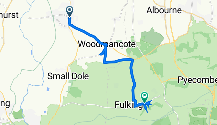
Bysshopps, High St, Henfield to Fulking Road, Poynings, Brighton
A cycling route starting in Henfield, England, United Kingdom.
Overview
About this route
- 37 min
- Duration
- 9.9 km
- Distance
- 162 m
- Ascent
- 125 m
- Descent
- 16.2 km/h
- Avg. speed
- 78 m
- Max. altitude

Route quality
Waytypes & surfaces along the route
Waytypes
Quiet road
3.7 km
(37 %)
Busy road
2.5 km
(26 %)
Surfaces
Paved
1.3 km
(13 %)
Unpaved
0.3 km
(3 %)
Asphalt
1.3 km
(13 %)
Ground
0.3 km
(3 %)
Undefined
8.3 km
(84 %)
Continue with Bikemap
Use, edit, or download this cycling route
You would like to ride Bysshopps, High St, Henfield to Fulking Road, Poynings, Brighton or customize it for your own trip? Here is what you can do with this Bikemap route:
Free features
- Save this route as favorite or in collections
- Copy & plan your own version of this route
- Sync your route with Garmin or Wahoo
Premium features
Free trial for 3 days, or one-time payment. More about Bikemap Premium.
- Navigate this route on iOS & Android
- Export a GPX / KML file of this route
- Create your custom printout (try it for free)
- Download this route for offline navigation
Discover more Premium features.
Get Bikemap PremiumFrom our community
Other popular routes starting in Henfield
 Field shop run.
- Distance
- 5.9 km
- Ascent
- 36 m
- Descent
- 36 m
- Location
- Henfield, England, United Kingdom
 Wantley Hill Estate 35 to Wantley Hill Estate 190
- Distance
- 28 km
- Ascent
- 89 m
- Descent
- 117 m
- Location
- Henfield, England, United Kingdom
 Bysshopps, High St, Henfield to Fulking Road, Poynings, Brighton
- Distance
- 9.9 km
- Ascent
- 162 m
- Descent
- 125 m
- Location
- Henfield, England, United Kingdom
 St. Anthonys Cottage, High St, Henfield to 3 The Vinery, St Mary's Road, Shoreham-By-Sea
- Distance
- 12.8 km
- Ascent
- 167 m
- Descent
- 188 m
- Location
- Henfield, England, United Kingdom
 Henfield To Steyning
- Distance
- 6.2 km
- Ascent
- 8 m
- Descent
- 31 m
- Location
- Henfield, England, United Kingdom
 Sandy Lane, Henfield to Victoria House, Sandy Lane, Henfield
- Distance
- 64.3 km
- Ascent
- 6 m
- Descent
- 22 m
- Location
- Henfield, England, United Kingdom
 PG n Back
- Distance
- 6.3 km
- Ascent
- 24 m
- Descent
- 24 m
- Location
- Henfield, England, United Kingdom
 Bridge and back
- Distance
- 9.9 km
- Ascent
- 31 m
- Descent
- 31 m
- Location
- Henfield, England, United Kingdom
Open it in the app