
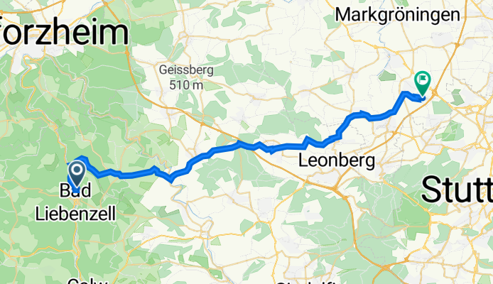
Forchenhalde 1, Bad Liebenzell nach Esslinger Weg 1, Korntal-Münchingen
A cycling route starting in Bad Liebenzell, Baden-Württemberg, Germany.
Overview
About this route
- 2 h 37 min
- Duration
- 37.3 km
- Distance
- 510 m
- Ascent
- 525 m
- Descent
- 14.3 km/h
- Avg. speed
- 503 m
- Max. altitude

Route quality
Waytypes & surfaces along the route
Waytypes
Quiet road
11.7 km
(31 %)
Track
10.9 km
(29 %)
Surfaces
Paved
35.6 km
(95 %)
Unpaved
1.1 km
(3 %)
Asphalt
34.7 km
(93 %)
Gravel
1 km
(3 %)
Continue with Bikemap
Use, edit, or download this cycling route
You would like to ride Forchenhalde 1, Bad Liebenzell nach Esslinger Weg 1, Korntal-Münchingen or customize it for your own trip? Here is what you can do with this Bikemap route:
Free features
- Save this route as favorite or in collections
- Copy & plan your own version of this route
- Sync your route with Garmin or Wahoo
Premium features
Free trial for 3 days, or one-time payment. More about Bikemap Premium.
- Navigate this route on iOS & Android
- Export a GPX / KML file of this route
- Create your custom printout (try it for free)
- Download this route for offline navigation
Discover more Premium features.
Get Bikemap PremiumFrom our community
Other popular routes starting in Bad Liebenzell
 Pforzheim und zurück im Nagoldtal
- Distance
- 44 km
- Ascent
- 460 m
- Descent
- 500 m
- Location
- Bad Liebenzell, Baden-Württemberg, Germany
 Olis Jungesellenabschied
- Distance
- 34.8 km
- Ascent
- 359 m
- Descent
- 435 m
- Location
- Bad Liebenzell, Baden-Württemberg, Germany
 MTB Bad Liebenzell
- Distance
- 49.8 km
- Ascent
- 947 m
- Descent
- 934 m
- Location
- Bad Liebenzell, Baden-Württemberg, Germany
 Unterhaugstett - Mercedes-Benz Sindelfingen
- Distance
- 23.4 km
- Ascent
- 134 m
- Descent
- 217 m
- Location
- Bad Liebenzell, Baden-Württemberg, Germany
 Rundkurs Kaltenbronner Wand
- Distance
- 104.3 km
- Ascent
- 2,316 m
- Descent
- 2,247 m
- Location
- Bad Liebenzell, Baden-Württemberg, Germany
 Schlehenweg, Bad Liebenzell nach Stuttgarter Straße, Bad Liebenzell
- Distance
- 14.2 km
- Ascent
- 216 m
- Descent
- 228 m
- Location
- Bad Liebenzell, Baden-Württemberg, Germany
 Runde Monbachta
- Distance
- 15.3 km
- Ascent
- 636 m
- Descent
- 635 m
- Location
- Bad Liebenzell, Baden-Württemberg, Germany
 rund um Liebenzell
- Distance
- 19.4 km
- Ascent
- 659 m
- Descent
- 654 m
- Location
- Bad Liebenzell, Baden-Württemberg, Germany
Open it in the app