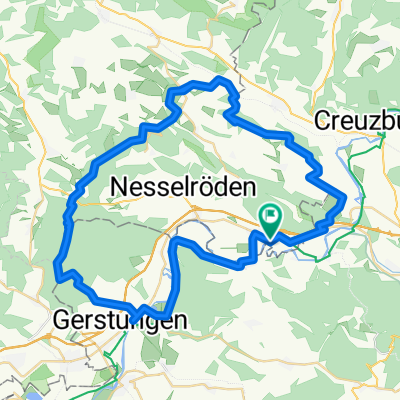
Unterellen - Vachaer Stein
A cycling route starting in Lauchröden, Free State of Thuringia, Germany.
Overview
About this route
Rundweg über Unterellen, Förtha und Oberellen
halb Wald/halb Straße
- -:--
- Duration
- 21.3 km
- Distance
- 265 m
- Ascent
- 265 m
- Descent
- ---
- Avg. speed
- ---
- Avg. speed
Continue with Bikemap
Use, edit, or download this cycling route
You would like to ride Unterellen - Vachaer Stein or customize it for your own trip? Here is what you can do with this Bikemap route:
Free features
- Save this route as favorite or in collections
- Copy & plan your own version of this route
- Sync your route with Garmin or Wahoo
Premium features
Free trial for 3 days, or one-time payment. More about Bikemap Premium.
- Navigate this route on iOS & Android
- Export a GPX / KML file of this route
- Create your custom printout (try it for free)
- Download this route for offline navigation
Discover more Premium features.
Get Bikemap PremiumFrom our community
Other popular routes starting in Lauchröden
- Große Runde
- Distance
- 38.3 km
- Ascent
- 261 m
- Descent
- 261 m
- Location
- Lauchröden, Free State of Thuringia, Germany
- Grenzerfahrungen Teil 06 #BETA#
- Distance
- 85.5 km
- Ascent
- 1,594 m
- Descent
- 1,594 m
- Location
- Lauchröden, Free State of Thuringia, Germany
- Dritter Tag auf dem Rennsteig 2013
- Distance
- 79.8 km
- Ascent
- 1,305 m
- Descent
- 913 m
- Location
- Lauchröden, Free State of Thuringia, Germany
- Am Rasenweg, Gerstungen nach Fritz-Koch-Straße 1, Eisenach
- Distance
- 16.2 km
- Ascent
- 85 m
- Descent
- 60 m
- Location
- Lauchröden, Free State of Thuringia, Germany
- 2. Etappe Badetag unter 100 km
- Distance
- 111.5 km
- Ascent
- 751 m
- Descent
- 815 m
- Location
- Lauchröden, Free State of Thuringia, Germany
- Unterellen - Vachaer Stein
- Distance
- 21.3 km
- Ascent
- 265 m
- Descent
- 265 m
- Location
- Lauchröden, Free State of Thuringia, Germany
- 2016-09-10: WTR - REN
- Distance
- 80.8 km
- Ascent
- 569 m
- Descent
- 560 m
- Location
- Lauchröden, Free State of Thuringia, Germany
- Werra Herleshausen - ESW
- Distance
- 57.8 km
- Ascent
- 363 m
- Descent
- 398 m
- Location
- Lauchröden, Free State of Thuringia, Germany
Open it in the app