
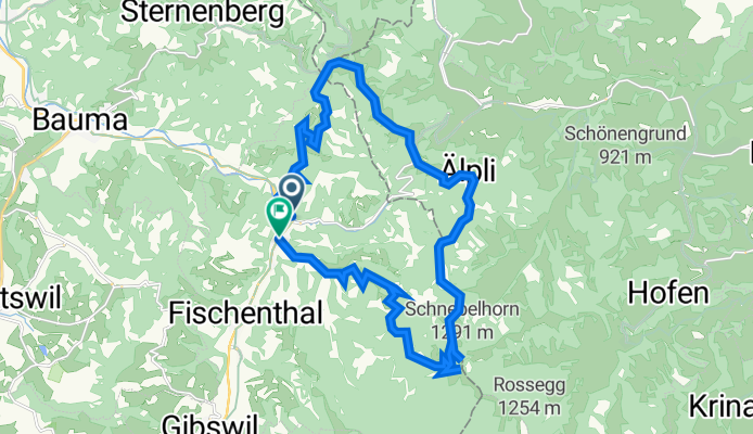
Steg-Hörnli-Schnebelhorn-Steg
A cycling route starting in Bauma, Canton of Zurich, Switzerland.
Overview
About this route
- -:--
- Duration
- 23.2 km
- Distance
- 1,223 m
- Ascent
- 1,211 m
- Descent
- ---
- Avg. speed
- 1,274 m
- Avg. speed
Continue with Bikemap
Use, edit, or download this cycling route
You would like to ride Steg-Hörnli-Schnebelhorn-Steg or customize it for your own trip? Here is what you can do with this Bikemap route:
Free features
- Save this route as favorite or in collections
- Copy & plan your own version of this route
- Sync your route with Garmin or Wahoo
Premium features
Free trial for 3 days, or one-time payment. More about Bikemap Premium.
- Navigate this route on iOS & Android
- Export a GPX / KML file of this route
- Create your custom printout (try it for free)
- Download this route for offline navigation
Discover more Premium features.
Get Bikemap PremiumFrom our community
Other popular routes starting in Bauma
 Bauma-Hombrechtikon-Rapperswil-Altendorf
- Distance
- 46.7 km
- Ascent
- 472 m
- Descent
- 687 m
- Location
- Bauma, Canton of Zurich, Switzerland
 Tössstock, Schnebelhorn
- Distance
- 26.3 km
- Ascent
- 901 m
- Descent
- 900 m
- Location
- Bauma, Canton of Zurich, Switzerland
 First-Heurüti-Hulftegg
- Distance
- 65.4 km
- Ascent
- 1,491 m
- Descent
- 1,475 m
- Location
- Bauma, Canton of Zurich, Switzerland
 Hörnli einfach
- Distance
- 4.1 km
- Ascent
- 476 m
- Descent
- 50 m
- Location
- Bauma, Canton of Zurich, Switzerland
 Bauma-Bergtraining länger
- Distance
- 83.9 km
- Ascent
- 2,325 m
- Descent
- 2,314 m
- Location
- Bauma, Canton of Zurich, Switzerland
 Bauma-Schnebelhorn
- Distance
- 42.5 km
- Ascent
- 1,280 m
- Descent
- 1,277 m
- Location
- Bauma, Canton of Zurich, Switzerland
 Bauma-Appenzell
- Distance
- 123.3 km
- Ascent
- 2,015 m
- Descent
- 2,075 m
- Location
- Bauma, Canton of Zurich, Switzerland
 Road cycling from Bauma
- Distance
- 38.4 km
- Ascent
- 712 m
- Descent
- 712 m
- Location
- Bauma, Canton of Zurich, Switzerland
Open it in the app