

NR959: Maasdünen und Reindersmeer
A cycling route starting in Weeze, North Rhine-Westphalia, Germany.
Overview
About this route
The tour takes us from the international airport of Weeze towards the German-Dutch border. Shortly after leaving the airport area, we make our first short stop and enjoy a view from a lookout point over a renatured gravel excavation.
Soon after, we reach the border, which only draws attention with a few traffic signs and the old customs house. A few meters further begins the Dutch national park 'De Maasduinen'.
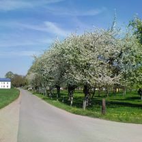
The Maasduinen are the longest river dune chain in the Netherlands. They extend from Arcen near Venlo for about 23 km northwest along the Maas river to Gennep. This uniquely beautiful landscape was put under protection and is today one of 21 national parks in the Netherlands. The landscape consists of dunes, wet meadows, forests, lakes, moors, pastures, and heathlands. In many places, herds of goats and sheep as well as Scottish Highland cattle graze to prevent scrub encroachment and to leave space for the heather. We roll comfortably over undulating terrain, often on soft forest floor and through pine groves, which in summer provide us not only with shade but also delight us with a pleasant fragrance.
At the visitors center 'De Maasduinen', where one can learn about the formation as well as flora and fauna, we make our second stop of the tour. The visitors center is located in a disused lock that connects the two former gravel lakes Leukermeer and Reindersmeer. While there are many tourist facilities at Leukersmeer, Reindersmeer is protected.
We continue along the Reindersmeer. Time and again we are treated to impressive views over the unspoiled lake and dune landscape. In the area of the Dutch village of Well, we leave the national park and pass the disused customs house again.
From here, we head towards the Weeze district of Wemb, to the last stop of the tour. At the farm café Winthuis, coffee and cake beckon. Strengthened, we then return to Weeze.
- -:--
- Duration
- 29.7 km
- Distance
- 120 m
- Ascent
- 118 m
- Descent
- ---
- Avg. speed
- 39 m
- Max. altitude

Route photos


Route quality
Waytypes & surfaces along the route
Waytypes
Path
9.5 km
(32 %)
Quiet road
8.6 km
(29 %)
Surfaces
Paved
18.1 km
(61 %)
Unpaved
5.9 km
(20 %)
Asphalt
18.1 km
(61 %)
Loose gravel
4.5 km
(15 %)
Route highlights
Points of interest along the route
Point of interest after 6.1 km
Aussichtspunkt
Point of interest after 14.9 km
Besucherzentrum Nationalpark "De Maasduinen"
Point of interest after 23.8 km
Bauerncafé Winthuis
Continue with Bikemap
Use, edit, or download this cycling route
You would like to ride NR959: Maasdünen und Reindersmeer or customize it for your own trip? Here is what you can do with this Bikemap route:
Free features
- Save this route as favorite or in collections
- Copy & plan your own version of this route
- Sync your route with Garmin or Wahoo
Premium features
Free trial for 3 days, or one-time payment. More about Bikemap Premium.
- Navigate this route on iOS & Android
- Export a GPX / KML file of this route
- Create your custom printout (try it for free)
- Download this route for offline navigation
Discover more Premium features.
Get Bikemap PremiumFrom our community
Other popular routes starting in Weeze
 NR397: Weeze - Uedem - Sonsbeck - Kevelaer - Weeze
- Distance
- 49.3 km
- Ascent
- 155 m
- Descent
- 156 m
- Location
- Weeze, North Rhine-Westphalia, Germany
 NR771: Weeze-Pfalzdorf-Reichswald-Kessel-Hassum-Weeze
- Distance
- 40 km
- Ascent
- 66 m
- Descent
- 66 m
- Location
- Weeze, North Rhine-Westphalia, Germany
 3 Tage Tour Weeze-Xanten-Hünxe Tag 3 54 km
- Distance
- 53.9 km
- Ascent
- 220 m
- Descent
- 203 m
- Location
- Weeze, North Rhine-Westphalia, Germany
 NR959: Maasdünen und Reindersmeer
- Distance
- 29.7 km
- Ascent
- 120 m
- Descent
- 118 m
- Location
- Weeze, North Rhine-Westphalia, Germany
 NR868: Reindersmeer, Maas und die Marienstadt
- Distance
- 37.2 km
- Ascent
- 125 m
- Descent
- 125 m
- Location
- Weeze, North Rhine-Westphalia, Germany
 NR942: Auf alten Bahntrassen in die Römerstadt Xanten
- Distance
- 56.9 km
- Ascent
- 195 m
- Descent
- 196 m
- Location
- Weeze, North Rhine-Westphalia, Germany
 NR416: Kendel-Tour
- Distance
- 32 km
- Ascent
- 6 m
- Descent
- 7 m
- Location
- Weeze, North Rhine-Westphalia, Germany
 Weeze– Enschede (via NL cities)
- Distance
- 129.3 km
- Ascent
- 0 m
- Descent
- 0 m
- Location
- Weeze, North Rhine-Westphalia, Germany
Open it in the app