
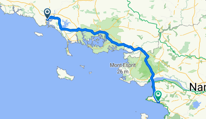


Lorient - Clohars-Fouesnant
- 90.4 km
- 763 m
- 744 m
- Lorient, Brittany Region, France
A cycling route starting in Lorient, Brittany Region, France.
Overview
<span style="font-size: 11.0pt; font-family: "Comic Sans MS"; mso-fareast-font-family: Calibri; mso-fareast-theme-font: minor-latin; mso-bidi-font-family: "Times New Roman"; mso-bidi-theme-font: minor-bidi; color: black; background: white; mso-ansi-language: FR; mso-fareast-language: EN-US; mso-bidi-language: AR-SA;" lang="FR">Mairie de Lorient</span><span style="font-size: 11.0pt; font-family: "Comic Sans MS"; mso-fareast-font-family: Calibri; mso-fareast-theme-font: minor-latin; mso-bidi-font-family: "Times New Roman"; mso-bidi-theme-font: minor-bidi; color: black; mso-ansi-language: FR; mso-fareast-language: EN-US; mso-bidi-language: AR-SA;" lang="FR"><br /> <span><span style="background: white;"><span style="float: none;">2 boulevard general leclerc</span></span></span><br /> <span><span style="background: white;"><span style="float: none;">56101 lorient cedex</span></span></span></span>
to
<span style="font-size: 11.0pt; font-family: "Comic Sans MS"; mso-fareast-font-family: Calibri; mso-fareast-theme-font: minor-latin; mso-bidi-font-family: "Times New Roman"; mso-bidi-theme-font: minor-bidi; color: black; background: white; mso-ansi-language: FR; mso-fareast-language: EN-US; mso-bidi-language: AR-SA;" lang="FR">Mairie de Pornic</span>
<span lang="FR"> <span style="color: black; font-family: 'Comic Sans MS'; font-size: 11pt;"><span style="background: white;"><span style="float: none;">place de l'hotel de ville</span></span></span><br /> <span style="color: black; font-family: 'Comic Sans MS'; font-size: 11pt;"><span style="background: white;"><span style="float: none;">bp 1409</span></span></span><br /> <span style="color: black; font-family: 'Comic Sans MS'; font-size: 11pt;"><span style="background: white;"><span style="float: none;">44210 pornic</span></span></span></span>
created this 14 years ago
Route quality
Quiet road
22.4 km
(14 %)
Cycleway
22.4 km
(14 %)
Paved
70.3 km
(44 %)
Unpaved
3.2 km
(2 %)
Asphalt
70.3 km
(44 %)
Gravel
1.6 km
(1 %)
Continue with Bikemap
You would like to ride X stage 25..... lorient - Pornic 16 Sept 2012 or customize it for your own trip? Here is what you can do with this Bikemap route:
Free trial for 3 days, or one-time payment. More about Bikemap Premium.
Discover more Premium features.
Get Bikemap PremiumFrom our community
Open it in the app


