
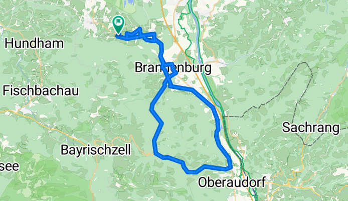
Oberaudorf-Tatzelwurm
A cycling route starting in Bad Feilnbach, Bavaria, Germany.
Overview
About this route
- -:--
- Duration
- 49.4 km
- Distance
- 494 m
- Ascent
- 494 m
- Descent
- ---
- Avg. speed
- ---
- Max. altitude
Route quality
Waytypes & surfaces along the route
Waytypes
Busy road
22.6 km
(46 %)
Quiet road
16.3 km
(33 %)
Surfaces
Paved
47.6 km
(96 %)
Unpaved
0.4 km
(<1 %)
Asphalt
47.6 km
(96 %)
Gravel
0.3 km
(<1 %)
Continue with Bikemap
Use, edit, or download this cycling route
You would like to ride Oberaudorf-Tatzelwurm or customize it for your own trip? Here is what you can do with this Bikemap route:
Free features
- Save this route as favorite or in collections
- Copy & plan your own version of this route
- Sync your route with Garmin or Wahoo
Premium features
Free trial for 3 days, or one-time payment. More about Bikemap Premium.
- Navigate this route on iOS & Android
- Export a GPX / KML file of this route
- Create your custom printout (try it for free)
- Download this route for offline navigation
Discover more Premium features.
Get Bikemap PremiumFrom our community
Other popular routes starting in Bad Feilnbach
 Von Bad Feilnbach zum Wendelstein und über die Tregleralm
- Distance
- 24.4 km
- Ascent
- 1,015 m
- Descent
- 1,015 m
- Location
- Bad Feilnbach, Bavaria, Germany
 tregler alm bad Aibling
- Distance
- 17.7 km
- Ascent
- 118 m
- Descent
- 585 m
- Location
- Bad Feilnbach, Bavaria, Germany
 Sulzberg-Wanderung
- Distance
- 9 km
- Ascent
- 678 m
- Descent
- 675 m
- Location
- Bad Feilnbach, Bavaria, Germany
 neue Auerbergkapelle
- Distance
- 30.5 km
- Ascent
- 527 m
- Descent
- 527 m
- Location
- Bad Feilnbach, Bavaria, Germany
 900hm
900hm- Distance
- 53.3 km
- Ascent
- 1,066 m
- Descent
- 878 m
- Location
- Bad Feilnbach, Bavaria, Germany
 Bad Feilnbach
- Distance
- 41.2 km
- Ascent
- 253 m
- Descent
- 253 m
- Location
- Bad Feilnbach, Bavaria, Germany
 Bad Feilnbach Spazierweg
- Distance
- 7.4 km
- Ascent
- 81 m
- Descent
- 81 m
- Location
- Bad Feilnbach, Bavaria, Germany
 Am Farrenpoint vorbeigeschrammt
- Distance
- 9.2 km
- Ascent
- 534 m
- Descent
- 533 m
- Location
- Bad Feilnbach, Bavaria, Germany
Open it in the app