

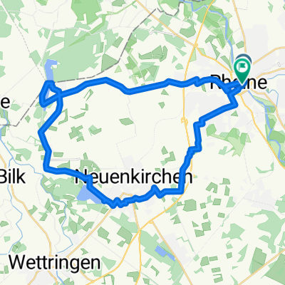
Hase-Ems-Radweg, Verbindungsstrecke Rheine-Osnabrück
A cycling route starting in Rheine, North Rhine-Westphalia, Germany.
Overview
About this route
Die Hase-Ems-Strecke geht über Osnabrück, Bersenbrück, Löningen, Meppen, Lingen und Rheine wieder zurück nach Osnabrück. Dieser Streckenabschnitt ist die Verbindung zwischen Rheine und Osnabrück. Der Weg ist beschildert mit weißem Schild auf dem ein Fahrrad. Die Räder zeigen die Hase in grüner Landschaft. Bin die Tour selber gefahren (über Hasetal Touristik gebucht,Langenstr. 33, 49624 Löningen, Tel.: 05432 599 599), sehr schöne Fahrt durch bäuerliche, naturreiche Landschaften und Wäldern. Diese Verbindungsstrecke führt Sie wieder an Ihren Ausgangspunkt zurück.
- -:--
- Duration
- 53.7 km
- Distance
- 168 m
- Ascent
- 131 m
- Descent
- ---
- Avg. speed
- ---
- Max. altitude
Continue with Bikemap
Use, edit, or download this cycling route
You would like to ride Hase-Ems-Radweg, Verbindungsstrecke Rheine-Osnabrück or customize it for your own trip? Here is what you can do with this Bikemap route:
Free features
- Save this route as favorite or in collections
- Copy & plan your own version of this route
- Sync your route with Garmin or Wahoo
Premium features
Free trial for 3 days, or one-time payment. More about Bikemap Premium.
- Navigate this route on iOS & Android
- Export a GPX / KML file of this route
- Create your custom printout (try it for free)
- Download this route for offline navigation
Discover more Premium features.
Get Bikemap PremiumFrom our community
Other popular routes starting in Rheine
 Rundstrecke Rheine Mesum Elte
- Distance
- 32.5 km
- Ascent
- 81 m
- Descent
- 81 m
- Location
- Rheine, North Rhine-Westphalia, Germany
 Hase-Ems-Weg - 1 Tag
- Distance
- 41.7 km
- Ascent
- 63 m
- Descent
- 75 m
- Location
- Rheine, North Rhine-Westphalia, Germany
 Rheine-Ewige Liebe
- Distance
- 29.9 km
- Ascent
- 72 m
- Descent
- 69 m
- Location
- Rheine, North Rhine-Westphalia, Germany
 Nasses Eck - Elte
- Distance
- 30 km
- Ascent
- 58 m
- Descent
- 56 m
- Location
- Rheine, North Rhine-Westphalia, Germany
 Rheine-Hörstel-Nasses Dreieck CLONED FROM ROUTE 71643
- Distance
- 32.4 km
- Ascent
- 61 m
- Descent
- 65 m
- Location
- Rheine, North Rhine-Westphalia, Germany
 Radbahn Münsterland
- Distance
- 36.4 km
- Ascent
- 101 m
- Descent
- 53 m
- Location
- Rheine, North Rhine-Westphalia, Germany
 Rheine-Tecklenburg
- Distance
- 73.5 km
- Ascent
- 285 m
- Descent
- 283 m
- Location
- Rheine, North Rhine-Westphalia, Germany
 Elte-Emsdetten-Neuenkirchen-Tour
- Distance
- 44.7 km
- Ascent
- 84 m
- Descent
- 83 m
- Location
- Rheine, North Rhine-Westphalia, Germany
Open it in the app