
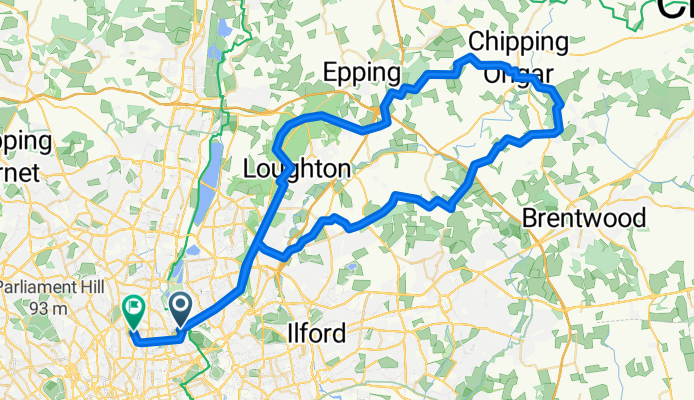
Road-North East London-75km
A cycling route starting in Hackney, England, United Kingdom.
Overview
About this route
- 4 h 49 min
- Duration
- 75.1 km
- Distance
- 664 m
- Ascent
- 643 m
- Descent
- 15.6 km/h
- Avg. speed
- 122 m
- Max. altitude

Route quality
Waytypes & surfaces along the route
Waytypes
Quiet road
24.8 km
(33 %)
Road
14.3 km
(19 %)
Surfaces
Paved
42.1 km
(56 %)
Asphalt
42.1 km
(56 %)
Undefined
33.1 km
(44 %)
Continue with Bikemap
Use, edit, or download this cycling route
You would like to ride Road-North East London-75km or customize it for your own trip? Here is what you can do with this Bikemap route:
Free features
- Save this route as favorite or in collections
- Copy & plan your own version of this route
- Sync your route with Garmin or Wahoo
Premium features
Free trial for 3 days, or one-time payment. More about Bikemap Premium.
- Navigate this route on iOS & Android
- Export a GPX / KML file of this route
- Create your custom printout (try it for free)
- Download this route for offline navigation
Discover more Premium features.
Get Bikemap PremiumFrom our community
Other popular routes starting in Hackney
 LFGSS Ride Out East
- Distance
- 111.2 km
- Ascent
- 437 m
- Descent
- 445 m
- Location
- Hackney, England, United Kingdom
 Grvl-Lee river East
- Distance
- 60.6 km
- Ascent
- 425 m
- Descent
- 409 m
- Location
- Hackney, England, United Kingdom
 Chingford Circular less off-road 2
- Distance
- 45.2 km
- Ascent
- 218 m
- Descent
- 217 m
- Location
- Hackney, England, United Kingdom
 Dunwich Dynamo 2009 CLONED FROM ROUTE 235147
- Distance
- 178 km
- Ascent
- 537 m
- Descent
- 554 m
- Location
- Hackney, England, United Kingdom
 Chingford Circular less off-road
- Distance
- 41.9 km
- Ascent
- 172 m
- Descent
- 171 m
- Location
- Hackney, England, United Kingdom
 Dunwich Dynamo 2016
- Distance
- 179.9 km
- Ascent
- 486 m
- Descent
- 505 m
- Location
- Hackney, England, United Kingdom
 London to Cambridge with wild swims
- Distance
- 93.9 km
- Ascent
- 292 m
- Descent
- 302 m
- Location
- Hackney, England, United Kingdom
 Epping Forest
- Distance
- 55.4 km
- Ascent
- 434 m
- Descent
- 434 m
- Location
- Hackney, England, United Kingdom
Open it in the app