

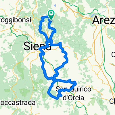
l'Eroica Gaiole_Short Route Gallo Nero_81km-1612hm_2021 by mnh
A cycling route starting in Gaiole in Chianti, Tuscany, Italy.
Overview
About this route
null
- -:--
- Duration
- 82.1 km
- Distance
- 2,210 m
- Ascent
- 2,210 m
- Descent
- ---
- Avg. speed
- 763 m
- Max. altitude

Route quality
Waytypes & surfaces along the route
Waytypes
Road
26.3 km
(32 %)
Quiet road
15.6 km
(19 %)
Surfaces
Paved
36.1 km
(44 %)
Unpaved
29.6 km
(36 %)
Asphalt
36.1 km
(44 %)
Gravel
20.5 km
(25 %)
Continue with Bikemap
Use, edit, or download this cycling route
You would like to ride l'Eroica Gaiole_Short Route Gallo Nero_81km-1612hm_2021 by mnh or customize it for your own trip? Here is what you can do with this Bikemap route:
Free features
- Save this route as favorite or in collections
- Copy & plan your own version of this route
- Split it into stages to create a multi-day tour
- Sync your route with Garmin or Wahoo
Premium features
Free trial for 3 days, or one-time payment. More about Bikemap Premium.
- Navigate this route on iOS & Android
- Export a GPX / KML file of this route
- Create your custom printout (try it for free)
- Download this route for offline navigation
Discover more Premium features.
Get Bikemap PremiumFrom our community
Other popular routes starting in Gaiole in Chianti
 Località Badia a Coltibuono nach Badia Coltibuono
- Distance
- 17.4 km
- Ascent
- 394 m
- Descent
- 455 m
- Location
- Gaiole in Chianti, Tuscany, Italy
 TERRA EROICA - L'Eroica (percorso completo/permanent route)
- Distance
- 207.1 km
- Ascent
- 2,997 m
- Descent
- 2,986 m
- Location
- Gaiole in Chianti, Tuscany, Italy
 Gaiole dream 1
- Distance
- 62.7 km
- Ascent
- 1,121 m
- Descent
- 1,121 m
- Location
- Gaiole in Chianti, Tuscany, Italy
 Radda / L'Eroica 20/07/2016
- Distance
- 41.8 km
- Ascent
- 797 m
- Descent
- 797 m
- Location
- Gaiole in Chianti, Tuscany, Italy
 Eroica_78km official (2014)
- Distance
- 77.9 km
- Ascent
- 1,363 m
- Descent
- 1,363 m
- Location
- Gaiole in Chianti, Tuscany, Italy
 L'Eroica 2016 - percorso 209 Km
- Distance
- 212.4 km
- Ascent
- 1,681 m
- Descent
- 1,663 m
- Location
- Gaiole in Chianti, Tuscany, Italy
 Route nach Badia Coltibuono -Castello di Brolo
- Distance
- 36.9 km
- Ascent
- 754 m
- Descent
- 806 m
- Location
- Gaiole in Chianti, Tuscany, Italy
 l'Eroica Gaiole_Short Route Gallo Nero_81km-1612hm_2021 by mnh
- Distance
- 82.1 km
- Ascent
- 2,210 m
- Descent
- 2,210 m
- Location
- Gaiole in Chianti, Tuscany, Italy
Open it in the app