

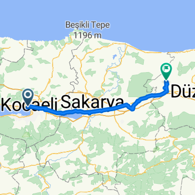
Izmit-Tavsansuyu
A cycling route starting in İzmit, Kocaeli Province, Republic of Türkiye.
Overview
About this route
- -:--
- Duration
- 100.9 km
- Distance
- 755 m
- Ascent
- 427 m
- Descent
- ---
- Avg. speed
- 362 m
- Max. altitude

Continue with Bikemap
Use, edit, or download this cycling route
You would like to ride Izmit-Tavsansuyu or customize it for your own trip? Here is what you can do with this Bikemap route:
Free features
- Save this route as favorite or in collections
- Copy & plan your own version of this route
- Split it into stages to create a multi-day tour
- Sync your route with Garmin or Wahoo
Premium features
Free trial for 3 days, or one-time payment. More about Bikemap Premium.
- Navigate this route on iOS & Android
- Export a GPX / KML file of this route
- Create your custom printout (try it for free)
- Download this route for offline navigation
Discover more Premium features.
Get Bikemap PremiumFrom our community
Other popular routes starting in İzmit
 izmit maşukiye sapanca arifiye adapazarı
- Distance
- 95.9 km
- Ascent
- 480 m
- Descent
- 481 m
- Location
- İzmit, Kocaeli Province, Republic of Türkiye
 Brief bike tour from Kabaoğlu to Kocaeli
- Distance
- 10.2 km
- Ascent
- 97 m
- Descent
- 445 m
- Location
- İzmit, Kocaeli Province, Republic of Türkiye
 HEREKE
- Distance
- 27.9 km
- Ascent
- 161 m
- Descent
- 157 m
- Location
- İzmit, Kocaeli Province, Republic of Türkiye
 Day 133
- Distance
- 48 km
- Ascent
- 425 m
- Descent
- 398 m
- Location
- İzmit, Kocaeli Province, Republic of Türkiye
 test
test- Distance
- 76.6 km
- Ascent
- 963 m
- Descent
- 870 m
- Location
- İzmit, Kocaeli Province, Republic of Türkiye
 BK1-Izmit-Dokuzdegirmen-119
- Distance
- 119 km
- Ascent
- 501 m
- Descent
- 403 m
- Location
- İzmit, Kocaeli Province, Republic of Türkiye
 izmit Gölcük ara yol
- Distance
- 15 km
- Ascent
- 89 m
- Descent
- 72 m
- Location
- İzmit, Kocaeli Province, Republic of Türkiye
 Tavşantepe Caddesi 148 to Cennet Sokak 2
- Distance
- 20 km
- Ascent
- 255 m
- Descent
- 262 m
- Location
- İzmit, Kocaeli Province, Republic of Türkiye
Open it in the app