

강남로95번길, 진주시 ~ 주약동 776-29, 진주시
A cycling route starting in Jinju, Gyeongsangnam-do, South Korea.
Overview
About this route
- 22 h 34 min
- Duration
- 48.2 km
- Distance
- 85 m
- Ascent
- 116 m
- Descent
- 2.1 km/h
- Avg. speed
- 57 m
- Max. altitude

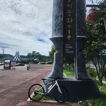
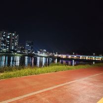
Route photos

Continue with Bikemap
Use, edit, or download this cycling route
You would like to ride 강남로95번길, 진주시 ~ 주약동 776-29, 진주시 or customize it for your own trip? Here is what you can do with this Bikemap route:
Free features
- Save this route as favorite or in collections
- Copy & plan your own version of this route
- Sync your route with Garmin or Wahoo
Premium features
Free trial for 3 days, or one-time payment. More about Bikemap Premium.
- Navigate this route on iOS & Android
- Export a GPX / KML file of this route
- Create your custom printout (try it for free)
- Download this route for offline navigation
Discover more Premium features.
Get Bikemap PremiumFrom our community
Other popular routes starting in Jinju
 강남로95번길, 진주시 ~ 주약동 776-29, 진주시
- Distance
- 48.2 km
- Ascent
- 85 m
- Descent
- 116 m
- Location
- Jinju, Gyeongsangnam-do, South Korea
![Ph0]에서 경로문산읍 1182-29, 진주시](https://media.bikemap.net/routes/13549834/staticmaps/in_d865ec26-a2ec-4832-8567-dd488c3bdebd_400x400_bikemap-2021-3D-static.png) Ph0]에서 경로문산읍 1182-29, 진주시
Ph0]에서 경로문산읍 1182-29, 진주시- Distance
- 7.1 km
- Ascent
- 31 m
- Descent
- 66 m
- Location
- Jinju, Gyeongsangnam-do, South Korea
 215, 진주시 to 내동면 산347, 진주시
- Distance
- 5.3 km
- Ascent
- 6 m
- Descent
- 3 m
- Location
- Jinju, Gyeongsangnam-do, South Korea
 45, 진주시 ~ 45, 진주시
- Distance
- 19.7 km
- Ascent
- 36 m
- Descent
- 65 m
- Location
- Jinju, Gyeongsangnam-do, South Korea
 내동유동마을
- Distance
- 24.3 km
- Ascent
- 64 m
- Descent
- 100 m
- Location
- Jinju, Gyeongsangnam-do, South Korea
 평거동 ~대평~평거동
- Distance
- 39.4 km
- Ascent
- 330 m
- Descent
- 343 m
- Location
- Jinju, Gyeongsangnam-do, South Korea
 진주역철길밑, 진주시 ~ 진주역철길밑, 진주시
- Distance
- 70 km
- Ascent
- 1,282 m
- Descent
- 1,277 m
- Location
- Jinju, Gyeongsangnam-do, South Korea
 평거동~김시민대교~촉석루~평거동
- Distance
- 29.4 km
- Ascent
- 269 m
- Descent
- 256 m
- Location
- Jinju, Gyeongsangnam-do, South Korea
Open it in the app