

VTT Chenaudière 4 Plaine Falle Champenay Bénaville 20 km d 574 Difficile.gpx_VTT Cheneaudière 4 - Plaine, La Falle, Champenay, Bénaville
A cycling route starting in Rothau, Grand Est, France.
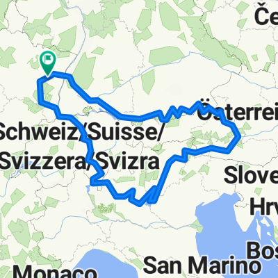
Overview
About this route
Metrics calculated from imported dataMonday, February 22, 2021 11:54 CETDistance: 21.1 kmDuration: 1 hour, 13 minutes and 56 secondsAverage speed: 17.1 km/hMinimum altitude: 419 mMaximum altitude: 631 mTotal positive elevation gain: 391 mTotal negative elevation gain: 391 m
- 1 h 58 min
- Duration
- 21.2 km
- Distance
- 472 m
- Ascent
- 475 m
- Descent
- 10.8 km/h
- Avg. speed
- 631 m
- Max. altitude
Route quality
Waytypes & surfaces along the route
Waytypes
Track
8.5 km
(40 %)
Road
4.2 km
(20 %)
Surfaces
Paved
3.8 km
(18 %)
Unpaved
7.6 km
(36 %)
Gravel
7.6 km
(36 %)
Asphalt
3.2 km
(15 %)
Continue with Bikemap
Use, edit, or download this cycling route
You would like to ride VTT Chenaudière 4 Plaine Falle Champenay Bénaville 20 km d 574 Difficile.gpx_VTT Cheneaudière 4 - Plaine, La Falle, Champenay, Bénaville or customize it for your own trip? Here is what you can do with this Bikemap route:
Free features
- Save this route as favorite or in collections
- Copy & plan your own version of this route
- Sync your route with Garmin or Wahoo
Premium features
Free trial for 3 days, or one-time payment. More about Bikemap Premium.
- Navigate this route on iOS & Android
- Export a GPX / KML file of this route
- Create your custom printout (try it for free)
- Download this route for offline navigation
Discover more Premium features.
Get Bikemap PremiumFrom our community
Other popular routes starting in Rothau
 Alpine Tour 2
- Distance
- 2,124.1 km
- Ascent
- 5,982 m
- Descent
- 5,986 m
- Location
- Rothau, Grand Est, France
 12137866-Entre Salm et le Ban de la Roche_VTT Cheneaudière 2 - Climont, Hang, Source de la Bruche
- Distance
- 25.1 km
- Ascent
- 680 m
- Descent
- 683 m
- Location
- Rothau, Grand Est, France
 2_Petit tour autour de Stampoumont-Ranrupt
- Distance
- 8 km
- Ascent
- 361 m
- Descent
- 361 m
- Location
- Rothau, Grand Est, France
 FR3HD-3a-gesamt-So-Vorm-Rennroute
- Distance
- 95.6 km
- Ascent
- 1,218 m
- Descent
- 1,502 m
- Location
- Rothau, Grand Est, France
 Neuviller01
- Distance
- 16.9 km
- Ascent
- 597 m
- Descent
- 597 m
- Location
- Rothau, Grand Est, France
 Rome, Etappe 4, Rothau - Möhlin (ZW)
- Distance
- 179.4 km
- Ascent
- 753 m
- Descent
- 811 m
- Location
- Rothau, Grand Est, France
 Boucle 40 km
- Distance
- 40.2 km
- Ascent
- 997 m
- Descent
- 997 m
- Location
- Rothau, Grand Est, France
 12137866-Entre Salm et le Ban de la Roche_VTT Cheneaudière 6 - Stampoumont, Bourg-Bruche, Saulxures, St. Blaise-la-Roche
- Distance
- 21 km
- Ascent
- 422 m
- Descent
- 422 m
- Location
- Rothau, Grand Est, France
Open it in the app