BT Bahntrassenwegrunde bis Burg
A cycling route starting in Bad Tatzmannsdorf, Burgenland, Austria.
Overview
About this route
Sehr schöne Bahntrasse von Oberschützen bis Oberwart dann gut markiert Straßen bis Grosspetersdorf und weiter die schöne Bahntrasse bis Rechnitz möglich
- 3 h 45 min
- Duration
- 58.3 km
- Distance
- 496 m
- Ascent
- 503 m
- Descent
- 15.5 km/h
- Avg. speed
- 409 m
- Avg. speed
Route quality
Waytypes & surfaces along the route
Waytypes
Quiet road
17.3 km
(30 %)
Road
16.3 km
(28 %)
Surfaces
Paved
30 km
(52 %)
Unpaved
1.9 km
(3 %)
Asphalt
27.5 km
(47 %)
Paved (undefined)
2.5 km
(4 %)
Continue with Bikemap
Use, edit, or download this cycling route
You would like to ride BT Bahntrassenwegrunde bis Burg or customize it for your own trip? Here is what you can do with this Bikemap route:
Free features
- Save this route as favorite or in collections
- Copy & plan your own version of this route
- Sync your route with Garmin or Wahoo
Premium features
Free trial for 3 days, or one-time payment. More about Bikemap Premium.
- Navigate this route on iOS & Android
- Export a GPX / KML file of this route
- Create your custom printout (try it for free)
- Download this route for offline navigation
Discover more Premium features.
Get Bikemap PremiumFrom our community
Other popular routes starting in Bad Tatzmannsdorf
- BadT_Pinka_Oberw_leicht
- Distance
- 34.7 km
- Ascent
- 125 m
- Descent
- 124 m
- Location
- Bad Tatzmannsdorf, Burgenland, Austria
- Am Kurplatz 2, Bad Tatzmannsdorf nach Am Kurplatz 2, Bad Tatzmannsdorf
- Distance
- 17.6 km
- Ascent
- 28 m
- Descent
- 61 m
- Location
- Bad Tatzmannsdorf, Burgenland, Austria
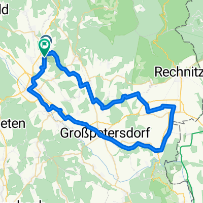
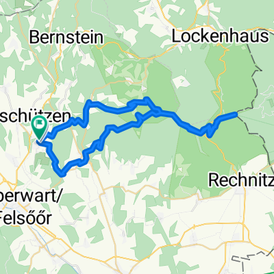
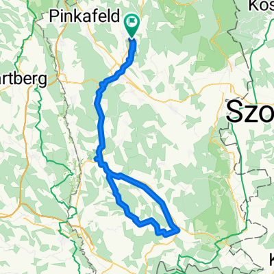
- Wilhelm-Simon-Promenade, Bad Tatzmannsdorf nach Am Golfplatz, Bad Tatzmannsdorf
- Distance
- 45.5 km
- Ascent
- 788 m
- Descent
- 785 m
- Location
- Bad Tatzmannsdorf, Burgenland, Austria
- BadT_Großpetersdorf_Kotezicken_St. Martin
- Distance
- 48.8 km
- Ascent
- 308 m
- Descent
- 308 m
- Location
- Bad Tatzmannsdorf, Burgenland, Austria
- BadT_kurze Ausfahrt_Eisenzicken_St.Martin
- Distance
- 20.6 km
- Ascent
- 208 m
- Descent
- 208 m
- Location
- Bad Tatzmannsdorf, Burgenland, Austria
- Edelserpentinweg
- Distance
- 24.4 km
- Ascent
- 493 m
- Descent
- 494 m
- Location
- Bad Tatzmannsdorf, Burgenland, Austria
- BT Bahntrassenwegrunde bis Burg
- Distance
- 58.3 km
- Ascent
- 496 m
- Descent
- 503 m
- Location
- Bad Tatzmannsdorf, Burgenland, Austria
- BadT_ganz kurze Ausfahrt_St.Martin
- Distance
- 18.2 km
- Ascent
- 151 m
- Descent
- 153 m
- Location
- Bad Tatzmannsdorf, Burgenland, Austria