

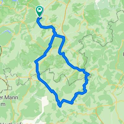
Schneifel-Tour
A cycling route starting in Kall, North Rhine-Westphalia, Germany.
Overview
About this route
A rather sporty tour from Kall to the heights of the Schee-Eifel to the Weißen Stein and back through Kronenburg, Dahlem, Marmagen.
- -:--
- Duration
- 80.3 km
- Distance
- 767 m
- Ascent
- 768 m
- Descent
- ---
- Avg. speed
- ---
- Max. altitude
Route quality
Waytypes & surfaces along the route
Waytypes
Track
18.5 km
(23 %)
Quiet road
12.1 km
(15 %)
Surfaces
Paved
49.8 km
(62 %)
Unpaved
4.8 km
(6 %)
Asphalt
41.8 km
(52 %)
Paved (undefined)
8 km
(10 %)
Route highlights
Points of interest along the route
Point of interest after 16 km
Wildenburg kann teilweise besichtigt werden. Unterhalb der Burg ein Cafe
Point of interest after 24.9 km
Bei Neuhaus markiert ein weithin sichtbarer Fernmeldeturm die Höhe
Point of interest after 33.6 km
Weißer Stein - Ski- und Wintersportgebiet der Eifel und mit ca. 690m höchste Erhebung der Schnee-Eifel
Point of interest after 48.7 km
Kronenburg - pittoreskes Stadtbild und Reste einer mittelalterlichen Festung.
Point of interest after 73.5 km
Kloster Steinfeld
Continue with Bikemap
Use, edit, or download this cycling route
You would like to ride Schneifel-Tour or customize it for your own trip? Here is what you can do with this Bikemap route:
Free features
- Save this route as favorite or in collections
- Copy & plan your own version of this route
- Split it into stages to create a multi-day tour
- Sync your route with Garmin or Wahoo
Premium features
Free trial for 3 days, or one-time payment. More about Bikemap Premium.
- Navigate this route on iOS & Android
- Export a GPX / KML file of this route
- Create your custom printout (try it for free)
- Download this route for offline navigation
Discover more Premium features.
Get Bikemap PremiumFrom our community
Other popular routes starting in Kall
 Lilienstraße nach Am Stellwerk
- Distance
- 103.8 km
- Ascent
- 736 m
- Descent
- 749 m
- Location
- Kall, North Rhine-Westphalia, Germany
 Rund um Mechernich
- Distance
- 41.2 km
- Ascent
- 503 m
- Descent
- 481 m
- Location
- Kall, North Rhine-Westphalia, Germany
 Schneifel-Tour
- Distance
- 80.3 km
- Ascent
- 767 m
- Descent
- 768 m
- Location
- Kall, North Rhine-Westphalia, Germany
 Gemünd-Talsperrenrunde-Heimbach
- Distance
- 39.5 km
- Ascent
- 399 m
- Descent
- 679 m
- Location
- Kall, North Rhine-Westphalia, Germany
 Kall Nordwest
- Distance
- 107.2 km
- Ascent
- 1,475 m
- Descent
- 1,475 m
- Location
- Kall, North Rhine-Westphalia, Germany
 Rursee Runde
- Distance
- 54.7 km
- Ascent
- 916 m
- Descent
- 921 m
- Location
- Kall, North Rhine-Westphalia, Germany
 bonnloire
- Distance
- 1,098.5 km
- Ascent
- 4,281 m
- Descent
- 4,659 m
- Location
- Kall, North Rhine-Westphalia, Germany
 Rund um die Eifel /Kall bis Kall ca. 90 km
- Distance
- 88.4 km
- Ascent
- 815 m
- Descent
- 815 m
- Location
- Kall, North Rhine-Westphalia, Germany
Open it in the app