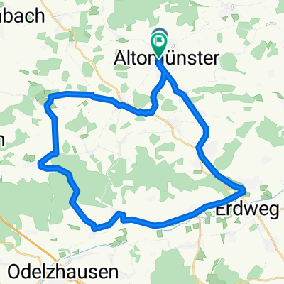
Bahnhofstraße 23, Altomünster to Altomünster, Altomünster
A cycling route starting in Altomünster, Bavaria, Germany.
Overview
About this route
- 4 h 12 min
- Duration
- 79.7 km
- Distance
- 796 m
- Ascent
- 797 m
- Descent
- 19 km/h
- Avg. speed
- 539 m
- Avg. speed
Route quality
Waytypes & surfaces along the route
Waytypes
Quiet road
34.9 km
(44 %)
Road
18.3 km
(23 %)
Surfaces
Paved
48.5 km
(61 %)
Unpaved
6.8 km
(8 %)
Asphalt
48.3 km
(61 %)
Gravel
4.3 km
(5 %)
Continue with Bikemap
Use, edit, or download this cycling route
You would like to ride Bahnhofstraße 23, Altomünster to Altomünster, Altomünster or customize it for your own trip? Here is what you can do with this Bikemap route:
Free features
- Save this route as favorite or in collections
- Copy & plan your own version of this route
- Sync your route with Garmin or Wahoo
Premium features
Free trial for 3 days, or one-time payment. More about Bikemap Premium.
- Navigate this route on iOS & Android
- Export a GPX / KML file of this route
- Create your custom printout (try it for free)
- Download this route for offline navigation
Discover more Premium features.
Get Bikemap PremiumFrom our community
Other popular routes starting in Altomünster
- Bahnhofstraße 23, Altomünster to Altomünster, Altomünster
- Distance
- 79.7 km
- Ascent
- 796 m
- Descent
- 797 m
- Location
- Altomünster, Bavaria, Germany
- Zwischen Indersdorf und Altomünster
- Distance
- 26.8 km
- Ascent
- 206 m
- Descent
- 209 m
- Location
- Altomünster, Bavaria, Germany
- Altomünster-Scheyern
- Distance
- 73.2 km
- Ascent
- 783 m
- Descent
- 784 m
- Location
- Altomünster, Bavaria, Germany
- Würzburg - Rom 2001 Tag 4 CLONED FROM ROUTE 1293929
- Distance
- 92 km
- Ascent
- 364 m
- Descent
- 251 m
- Location
- Altomünster, Bavaria, Germany
- Alto-Klingen-Aufhausen-Pipinsried-Alto
- Distance
- 31.9 km
- Ascent
- ---
- Descent
- ---
- Location
- Altomünster, Bavaria, Germany
- Altomünster - Freising
- Distance
- 45.6 km
- Ascent
- 141 m
- Descent
- 198 m
- Location
- Altomünster, Bavaria, Germany
- Route von Halmsrieder Straße 1, Altomünster
- Distance
- 21.8 km
- Ascent
- 219 m
- Descent
- 214 m
- Location
- Altomünster, Bavaria, Germany
- Alto-Blumenthal-Schmarnzell-Alto
- Distance
- 32.6 km
- Ascent
- 373 m
- Descent
- 417 m
- Location
- Altomünster, Bavaria, Germany
Open it in the app