

Lahmen Hasen V3
A cycling route starting in Witten, North Rhine-Westphalia, Germany.
Overview
About this route
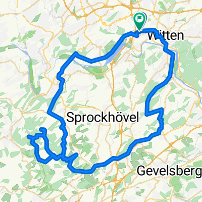
Ride to Lahmen Hasen. Then southwards behind Lüdenscheid and back to Bochum via Halver, Schwelm, and Sprockhövel.
- -:--
- Duration
- 109.4 km
- Distance
- 842 m
- Ascent
- 841 m
- Descent
- ---
- Avg. speed
- ---
- Max. altitude
Continue with Bikemap
Use, edit, or download this cycling route
You would like to ride Lahmen Hasen V3 or customize it for your own trip? Here is what you can do with this Bikemap route:
Free features
- Save this route as favorite or in collections
- Copy & plan your own version of this route
- Split it into stages to create a multi-day tour
- Sync your route with Garmin or Wahoo
Premium features
Free trial for 3 days, or one-time payment. More about Bikemap Premium.
- Navigate this route on iOS & Android
- Export a GPX / KML file of this route
- Create your custom printout (try it for free)
- Download this route for offline navigation
Discover more Premium features.
Get Bikemap PremiumFrom our community
Other popular routes starting in Witten
 Wittener RTF 2008 71er
- Distance
- 70.2 km
- Ascent
- 662 m
- Descent
- 628 m
- Location
- Witten, North Rhine-Westphalia, Germany
 RV Flottweg Bochum Ruhr-Lenne-Permanente RTF
- Distance
- 73.2 km
- Ascent
- 455 m
- Descent
- 448 m
- Location
- Witten, North Rhine-Westphalia, Germany
 Witten-Hohenstein
- Distance
- 13.3 km
- Ascent
- 277 m
- Descent
- 277 m
- Location
- Witten, North Rhine-Westphalia, Germany
 Witten-Essen-Witten
- Distance
- 93.8 km
- Ascent
- 272 m
- Descent
- 272 m
- Location
- Witten, North Rhine-Westphalia, Germany
 Frackmannsfeld, Witten nach Graf-Engelbert-Weg, Hattingen
- Distance
- 65.3 km
- Ascent
- 1,093 m
- Descent
- 1,095 m
- Location
- Witten, North Rhine-Westphalia, Germany
 Hohensyburg
- Distance
- 33.7 km
- Ascent
- 517 m
- Descent
- 517 m
- Location
- Witten, North Rhine-Westphalia, Germany
 ketteimmerrechts.de // kir-ig.de
- Distance
- 49.7 km
- Ascent
- 455 m
- Descent
- 458 m
- Location
- Witten, North Rhine-Westphalia, Germany
 Mittlere Route Langendreer - Stockum
- Distance
- 11.4 km
- Ascent
- 91 m
- Descent
- 85 m
- Location
- Witten, North Rhine-Westphalia, Germany
Open it in the app