

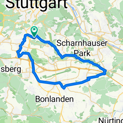
Hausstrecke
A cycling route starting in Leinfelden-Echterdingen, Baden-Wurttemberg, Germany.
Overview
About this route
Vaihingen-Büsnau-Magstadt-Ihingerhof-Stubenberghöfe-Schafhausen-Dätzingen-Aidlingen-Ehningen-Mauren-Holzgerlingen-Schönaich-Böblingen-Vaihingen.
- -:--
- Duration
- 56.2 km
- Distance
- 505 m
- Ascent
- 482 m
- Descent
- ---
- Avg. speed
- 502 m
- Max. altitude

Route quality
Waytypes & surfaces along the route
Waytypes
Road
33 km
(59 %)
Busy road
10.7 km
(19 %)
Surfaces
Paved
52.4 km
(93 %)
Unpaved
1.7 km
(3 %)
Asphalt
50.9 km
(91 %)
Concrete
1 km
(2 %)
Continue with Bikemap
Use, edit, or download this cycling route
You would like to ride Hausstrecke or customize it for your own trip? Here is what you can do with this Bikemap route:
Free features
- Save this route as favorite or in collections
- Copy & plan your own version of this route
- Sync your route with Garmin or Wahoo
Premium features
Free trial for 3 days, or one-time payment. More about Bikemap Premium.
- Navigate this route on iOS & Android
- Export a GPX / KML file of this route
- Create your custom printout (try it for free)
- Download this route for offline navigation
Discover more Premium features.
Get Bikemap PremiumFrom our community
Other popular routes starting in Leinfelden-Echterdingen
 Möhringen - Sindelfingen/KevinKugel 32km
- Distance
- 32.1 km
- Ascent
- 349 m
- Descent
- 353 m
- Location
- Leinfelden-Echterdingen, Baden-Wurttemberg, Germany
 Rundstrecke Hoffeld-Denkendorf-Hoffeld
- Distance
- 36.7 km
- Ascent
- 238 m
- Descent
- 259 m
- Location
- Leinfelden-Echterdingen, Baden-Wurttemberg, Germany
 Filderradrunde
- Distance
- 56.9 km
- Ascent
- 476 m
- Descent
- 474 m
- Location
- Leinfelden-Echterdingen, Baden-Wurttemberg, Germany
 Möhringen 49km Mitte BW_Maichingen Dagersheim Böblingen Römerstr. 490hm
- Distance
- 48.9 km
- Ascent
- 348 m
- Descent
- 353 m
- Location
- Leinfelden-Echterdingen, Baden-Wurttemberg, Germany
 Hausstrecke
- Distance
- 56.2 km
- Ascent
- 505 m
- Descent
- 482 m
- Location
- Leinfelden-Echterdingen, Baden-Wurttemberg, Germany
 Möhringen - Reutlingen grün 42km 430hm
- Distance
- 42.6 km
- Ascent
- 388 m
- Descent
- 423 m
- Location
- Leinfelden-Echterdingen, Baden-Wurttemberg, Germany
 2009-06-18 MTB
- Distance
- 35.4 km
- Ascent
- 529 m
- Descent
- 529 m
- Location
- Leinfelden-Echterdingen, Baden-Wurttemberg, Germany
 Rund um Böblingen
- Distance
- 65.7 km
- Ascent
- 604 m
- Descent
- 654 m
- Location
- Leinfelden-Echterdingen, Baden-Wurttemberg, Germany
Open it in the app