
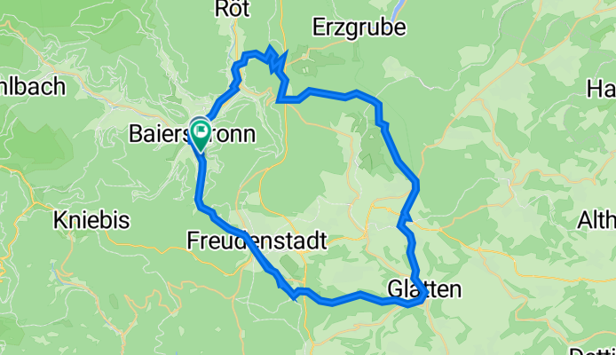
Baiersbronn-Hallwangen-Lauterbadhütte-Freudenstadt-Baiersbronn
A cycling route starting in Baiersbronn, Baden-Württemberg, Germany.
Overview
About this route
- 4 h 49 min
- Duration
- 43.6 km
- Distance
- 816 m
- Ascent
- 813 m
- Descent
- 9.1 km/h
- Avg. speed
- 788 m
- Max. altitude

Route quality
Waytypes & surfaces along the route
Waytypes
Track
25.1 km
(58 %)
Quiet road
11.3 km
(26 %)
Surfaces
Paved
20.3 km
(47 %)
Unpaved
19.4 km
(45 %)
Asphalt
18.7 km
(43 %)
Gravel
11.2 km
(26 %)
Continue with Bikemap
Use, edit, or download this cycling route
You would like to ride Baiersbronn-Hallwangen-Lauterbadhütte-Freudenstadt-Baiersbronn or customize it for your own trip? Here is what you can do with this Bikemap route:
Free features
- Save this route as favorite or in collections
- Copy & plan your own version of this route
- Sync your route with Garmin or Wahoo
Premium features
Free trial for 3 days, or one-time payment. More about Bikemap Premium.
- Navigate this route on iOS & Android
- Export a GPX / KML file of this route
- Create your custom printout (try it for free)
- Download this route for offline navigation
Discover more Premium features.
Get Bikemap PremiumFrom our community
Other popular routes starting in Baiersbronn
 Baiersbronn - klein
- Distance
- 46.4 km
- Ascent
- 1,098 m
- Descent
- 1,098 m
- Location
- Baiersbronn, Baden-Württemberg, Germany
 Murgtal - Karlsruhe
- Distance
- 88.1 km
- Ascent
- 92 m
- Descent
- 523 m
- Location
- Baiersbronn, Baden-Württemberg, Germany
 Buhlbach, Buhlbachsee, Buhlbach, Mitteltal, Burgkopf,
- Distance
- 33 km
- Ascent
- 672 m
- Descent
- 671 m
- Location
- Baiersbronn, Baden-Württemberg, Germany
 2025-2-3-Baiersbronn bis Wolfach
- Distance
- 66.6 km
- Ascent
- 1,811 m
- Descent
- 2,135 m
- Location
- Baiersbronn, Baden-Württemberg, Germany
 Baiersbronner T3 Huzenbacher-See-Tour
- Distance
- 51.1 km
- Ascent
- 1,536 m
- Descent
- 1,538 m
- Location
- Baiersbronn, Baden-Württemberg, Germany
 MB - Der Seensteig in Baiersbronn, eine Premiumroute im Schwarzwald
- Distance
- 85.9 km
- Ascent
- 1,645 m
- Descent
- 1,645 m
- Location
- Baiersbronn, Baden-Württemberg, Germany
 Oberdorfstraße 142, Baiersbronn über Sankenbach-Wasserfall nach Oberdorfstraße 142, Baiersbronn
- Distance
- 14.9 km
- Ascent
- 339 m
- Descent
- 360 m
- Location
- Baiersbronn, Baden-Württemberg, Germany
 Tour Schwarzwald - Baiersbronn
- Distance
- 47.6 km
- Ascent
- 1,044 m
- Descent
- 945 m
- Location
- Baiersbronn, Baden-Württemberg, Germany
Open it in the app