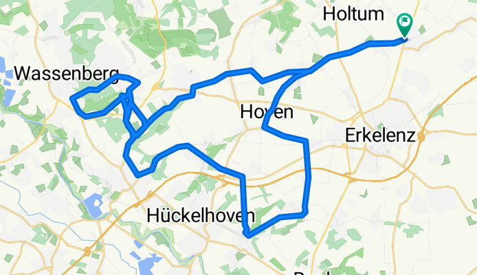
Sieben-Hügel-Tour
A cycling route starting in Erkelenz, North Rhine-Westphalia, Germany.
Overview
About this route
Nette Hügelrunde durch das Grenzland. Erst ein bißchen warmfahren und dann der Reihe nach die Anstiege in Doveren, Kleingladbach, sowie die Altmyhler, Myhler und Wassenberger Anstiege. Die Route geht über ruhige Nebenstraßen und ist Ampelfrei, Nur ein paar mal müssen Hauptverkehrsstraßen gekreuzt werden.
- -:--
- Duration
- 45.6 km
- Distance
- 213 m
- Ascent
- 208 m
- Descent
- ---
- Avg. speed
- 96 m
- Avg. speed
Route quality
Waytypes & surfaces along the route
Waytypes
Busy road
16.4 km
(36 %)
Path
7.8 km
(17 %)
Surfaces
Paved
15.6 km
(34 %)
Unpaved
2.7 km
(6 %)
Asphalt
13.6 km
(30 %)
Paved (undefined)
1.7 km
(4 %)
Continue with Bikemap
Use, edit, or download this cycling route
You would like to ride Sieben-Hügel-Tour or customize it for your own trip? Here is what you can do with this Bikemap route:
Free features
- Save this route as favorite or in collections
- Copy & plan your own version of this route
- Sync your route with Garmin or Wahoo
Premium features
Free trial for 3 days, or one-time payment. More about Bikemap Premium.
- Navigate this route on iOS & Android
- Export a GPX / KML file of this route
- Create your custom printout (try it for free)
- Download this route for offline navigation
Discover more Premium features.
Get Bikemap PremiumFrom our community
Other popular routes starting in Erkelenz
- Grenzrunde
- Distance
- 86.7 km
- Ascent
- 365 m
- Descent
- 373 m
- Location
- Erkelenz, North Rhine-Westphalia, Germany
- RTF Erkelenz 2010 - 111 km Strecke - Erkelenzer RTF 2010
- Distance
- 107.1 km
- Ascent
- 187 m
- Descent
- 187 m
- Location
- Erkelenz, North Rhine-Westphalia, Germany
- 6 Bellinghoven - Metternich
- Distance
- 65.6 km
- Ascent
- 118 m
- Descent
- 88 m
- Location
- Erkelenz, North Rhine-Westphalia, Germany
- 21.05.2025 Ride of Silence Mönchengladbach, START 18:00 Uhr am Ghostbike Venrather Str./Herrather Weg
- Distance
- 30.1 km
- Ascent
- 22 m
- Descent
- 46 m
- Location
- Erkelenz, North Rhine-Westphalia, Germany
- Von Erkelenz bis Linnich
- Distance
- 12 km
- Ascent
- 30 m
- Descent
- 43 m
- Location
- Erkelenz, North Rhine-Westphalia, Germany
- ERK Mackenstein Brempt Wegberg 54 km
- Distance
- 55.7 km
- Ascent
- 86 m
- Descent
- 86 m
- Location
- Erkelenz, North Rhine-Westphalia, Germany
- Sophienhöhe / Tagebau Hambach
- Distance
- 91 km
- Ascent
- 156 m
- Descent
- 183 m
- Location
- Erkelenz, North Rhine-Westphalia, Germany
- Erkelenz nach Grevenbroich 24 km
- Distance
- 24.2 km
- Ascent
- 49 m
- Descent
- 95 m
- Location
- Erkelenz, North Rhine-Westphalia, Germany