
Müller mahle mein Mehl
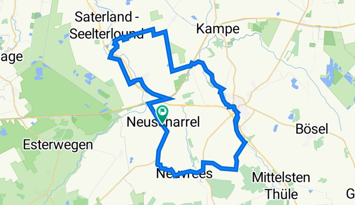
A cycling route starting in Hilkenbrook, Lower Saxony, Germany.
Overview
About this route
- 2 h 53 min
- Duration
- 48.4 km
- Distance
- 0 m
- Ascent
- 0 m
- Descent
- 16.8 km/h
- Avg. speed
- 0 m
- Max. altitude

Route quality
Waytypes & surfaces along the route
Waytypes
Quiet road
31.5 km
(65 %)
Path
8.2 km
(17 %)
Surfaces
Paved
34.4 km
(71 %)
Unpaved
0.5 km
(1 %)
Asphalt
34.4 km
(71 %)
Gravel
0.5 km
(1 %)
Undefined
13.6 km
(28 %)
Continue with Bikemap
Use, edit, or download this cycling route
You would like to ride Müller mahle mein Mehl or customize it for your own trip? Here is what you can do with this Bikemap route:
Free features
- Save this route as favorite or in collections
- Copy & plan your own version of this route
- Sync your route with Garmin or Wahoo
Premium features
Free trial for 3 days, or one-time payment. More about Bikemap Premium.
- Navigate this route on iOS & Android
- Export a GPX / KML file of this route
- Create your custom printout (try it for free)
- Download this route for offline navigation
Discover more Premium features.
Get Bikemap PremiumFrom our community
Other popular routes starting in Hilkenbrook
 Müller mahle mein Mehl
- Distance
- 48.4 km
- Ascent
- 0 m
- Descent
- 0 m
- Location
- Hilkenbrook, Lower Saxony, Germany
 Mario
Mario- Distance
- 45.1 km
- Ascent
- 22 m
- Descent
- 24 m
- Location
- Hilkenbrook, Lower Saxony, Germany
 Wanderweg "Sedelsberg3"
- Distance
- 2.7 km
- Ascent
- 0 m
- Descent
- 4 m
- Location
- Hilkenbrook, Lower Saxony, Germany
 Walters Tour 002
- Distance
- 75.5 km
- Ascent
- 132 m
- Descent
- 119 m
- Location
- Hilkenbrook, Lower Saxony, Germany
 Etappe 1 von Neuvrees nach Meppen
- Distance
- 68.6 km
- Ascent
- 103 m
- Descent
- 103 m
- Location
- Hilkenbrook, Lower Saxony, Germany
 Kirchentour Gemeinde Saterland
- Distance
- 35.9 km
- Ascent
- 9 m
- Descent
- 9 m
- Location
- Hilkenbrook, Lower Saxony, Germany
 testing
- Distance
- 8.2 km
- Ascent
- 11 m
- Descent
- 14 m
- Location
- Hilkenbrook, Lower Saxony, Germany
 Kreuz und quer durch den Eleonorenwald
- Distance
- 31.2 km
- Ascent
- 48 m
- Descent
- 48 m
- Location
- Hilkenbrook, Lower Saxony, Germany
Open it in the app