
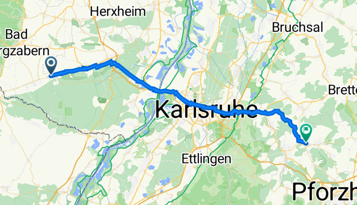
Schaidt-KA-Koe-Stein
A cycling route starting in Vollmersweiler, Rhineland-Palatinate, Germany.
Overview
About this route
- -:--
- Duration
- 49.6 km
- Distance
- 289 m
- Ascent
- 250 m
- Descent
- ---
- Avg. speed
- 265 m
- Max. altitude

Route quality
Waytypes & surfaces along the route
Waytypes
Quiet road
14.9 km
(30 %)
Track
11.9 km
(24 %)
Surfaces
Paved
44.2 km
(89 %)
Unpaved
2.5 km
(5 %)
Asphalt
38.7 km
(78 %)
Concrete
3.5 km
(7 %)
Continue with Bikemap
Use, edit, or download this cycling route
You would like to ride Schaidt-KA-Koe-Stein or customize it for your own trip? Here is what you can do with this Bikemap route:
Free features
- Save this route as favorite or in collections
- Copy & plan your own version of this route
- Sync your route with Garmin or Wahoo
Premium features
Free trial for 3 days, or one-time payment. More about Bikemap Premium.
- Navigate this route on iOS & Android
- Export a GPX / KML file of this route
- Create your custom printout (try it for free)
- Download this route for offline navigation
Discover more Premium features.
Get Bikemap PremiumFrom our community
Other popular routes starting in Vollmersweiler
 Riesling und Zander
- Distance
- 53 km
- Ascent
- 174 m
- Descent
- 175 m
- Location
- Vollmersweiler, Rhineland-Palatinate, Germany
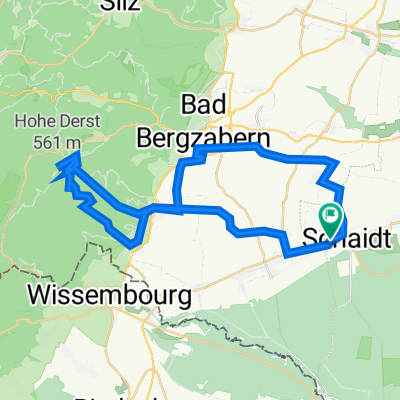 2023-03-11_Hohe-Derst
- Distance
- 41.7 km
- Ascent
- 676 m
- Descent
- 679 m
- Location
- Vollmersweiler, Rhineland-Palatinate, Germany
 Schaidt-KA-Koe-Stein
- Distance
- 49.6 km
- Ascent
- 289 m
- Descent
- 250 m
- Location
- Vollmersweiler, Rhineland-Palatinate, Germany
 Bienwald
- Distance
- 8.3 km
- Ascent
- 52 m
- Descent
- 53 m
- Location
- Vollmersweiler, Rhineland-Palatinate, Germany
 Lauterburg
- Distance
- 43 km
- Ascent
- 86 m
- Descent
- 86 m
- Location
- Vollmersweiler, Rhineland-Palatinate, Germany
 Impflingen
- Distance
- 34.8 km
- Ascent
- 177 m
- Descent
- 178 m
- Location
- Vollmersweiler, Rhineland-Palatinate, Germany
 Westwall-Wanderweg
- Distance
- 11.2 km
- Ascent
- 60 m
- Descent
- 59 m
- Location
- Vollmersweiler, Rhineland-Palatinate, Germany
 Oberotterbach - Weißenburg
- Distance
- 30.9 km
- Ascent
- 161 m
- Descent
- 160 m
- Location
- Vollmersweiler, Rhineland-Palatinate, Germany
Open it in the app