

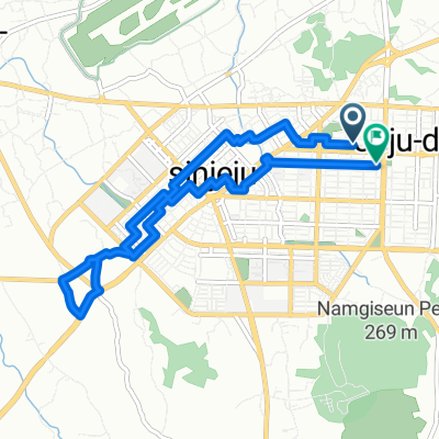
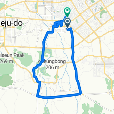
Jeju Fantasy Trail Counterclockwise
A cycling route starting in Jeju City, Jeju-do, South Korea.
Overview
About this route
- -:--
- Duration
- 231.8 km
- Distance
- 1,200 m
- Ascent
- 1,204 m
- Descent
- ---
- Avg. speed
- 165 m
- Max. altitude
Route quality
Waytypes & surfaces along the route
Waytypes
Road
143.7 km
(62 %)
Quiet road
23.2 km
(10 %)
Surfaces
Paved
34.8 km
(15 %)
Paved (undefined)
18.5 km
(8 %)
Asphalt
16.2 km
(7 %)
Undefined
197.1 km
(85 %)
Route highlights
Points of interest along the route
Point of interest after 0.1 km
1. Stamp Booth Yongduam
Point of interest after 21.1 km
2. Stamp Booth Darak Shelter
Accommodation after 37.3 km
1. Night: Hyopjae Beach
Point of interest after 41.8 km
3. Stamp Booth Haegeoreum Park
Point of interest after 75.2 km
4. Stamp booth, Songaksan
Accommodation after 93.7 km
#2. Night: Jungmun Saekdal Beach
Point of interest after 105.7 km
5. Stamp Booth Beophwan Badang
Point of interest after 119.3 km
6. Stamp Booth Seosokkak
Point of interest after 148.1 km
7. Stamp booth Pyoseon beach
Accommodation after 164.6 km
#3 Night: Seopjikoji
Point of interest after 168.9 km
8. Stamp booth Seongsan Ilchulbong
Accommodation after 177.2 km
#3 Night: Hado heabyeon (alternative)
Point of interest after 197 km
9. Stamp booth Gimnyeong Seongsegi beach
Point of interest after 207.5 km
10. Stamp booth Gamdeok Seubong beach
Continue with Bikemap
Use, edit, or download this cycling route
You would like to ride Jeju Fantasy Trail Counterclockwise or customize it for your own trip? Here is what you can do with this Bikemap route:
Free features
- Save this route as favorite or in collections
- Copy & plan your own version of this route
- Split it into stages to create a multi-day tour
- Sync your route with Garmin or Wahoo
Premium features
Free trial for 3 days, or one-time payment. More about Bikemap Premium.
- Navigate this route on iOS & Android
- Export a GPX / KML file of this route
- Create your custom printout (try it for free)
- Download this route for offline navigation
Discover more Premium features.
Get Bikemap PremiumFrom our community
Other popular routes starting in Jeju City
 연동 291-49 ~ 연동 291-49
- Distance
- 8.9 km
- Ascent
- 82 m
- Descent
- 79 m
- Location
- Jeju City, Jeju-do, South Korea
 Day 1
Day 1- Distance
- 65.3 km
- Ascent
- 179 m
- Descent
- 206 m
- Location
- Jeju City, Jeju-do, South Korea
 신촌에서부터 돌아오기
- Distance
- 6.5 km
- Ascent
- 60 m
- Descent
- 65 m
- Location
- Jeju City, Jeju-do, South Korea
 도남로, 제주시에서 도남동, 제주시까지
- Distance
- 12.8 km
- Ascent
- 251 m
- Descent
- 286 m
- Location
- Jeju City, Jeju-do, South Korea
 제주시내 라이딩 혼자
- Distance
- 28.2 km
- Ascent
- 273 m
- Descent
- 298 m
- Location
- Jeju City, Jeju-do, South Korea
 도두일동 2616-3, 제주시 to 도두일동 2617-2, 제주시
- Distance
- 13 km
- Ascent
- 134 m
- Descent
- 131 m
- Location
- Jeju City, Jeju-do, South Korea
 대원길, 제주시에서 대원길, 제주시까지
- Distance
- 106.7 km
- Ascent
- 1,649 m
- Descent
- 1,628 m
- Location
- Jeju City, Jeju-do, South Korea
![Ph0]에서 경로월평동 999-1](https://media.bikemap.net/routes/17659864/staticmaps/in_0eb7a881-14bb-4140-8e6e-4b92c59f2a49_400x400_bikemap-2021-3D-static.png) Ph0]에서 경로월평동 999-1
Ph0]에서 경로월평동 999-1- Distance
- 114.7 km
- Ascent
- 1,991 m
- Descent
- 2,169 m
- Location
- Jeju City, Jeju-do, South Korea
Open it in the app