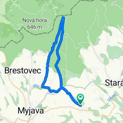
Vrbovce do Vrbovce
A cycling route starting in Myjava, Trenčiansky kraj, Slovak Republic.
Overview
About this route
- 1 h 2 min
- Duration
- 18.9 km
- Distance
- 254 m
- Ascent
- 297 m
- Descent
- 18.2 km/h
- Avg. speed
- 464 m
- Avg. speed
Route photos
Route quality
Waytypes & surfaces along the route
Waytypes
Busy road
7.2 km
(38 %)
Track
4.2 km
(22 %)
Surfaces
Paved
7.6 km
(40 %)
Unpaved
1.6 km
(9 %)
Asphalt
7.6 km
(40 %)
Ground
1.4 km
(7 %)
Continue with Bikemap
Use, edit, or download this cycling route
You would like to ride Vrbovce do Vrbovce or customize it for your own trip? Here is what you can do with this Bikemap route:
Free features
- Save this route as favorite or in collections
- Copy & plan your own version of this route
- Sync your route with Garmin or Wahoo
Premium features
Free trial for 3 days, or one-time payment. More about Bikemap Premium.
- Navigate this route on iOS & Android
- Export a GPX / KML file of this route
- Create your custom printout (try it for free)
- Download this route for offline navigation
Discover more Premium features.
Get Bikemap PremiumFrom our community
Other popular routes starting in Myjava
- Myjava - Bašnárovci - Prietrž
- Distance
- 16.3 km
- Ascent
- 213 m
- Descent
- 283 m
- Location
- Myjava, Trenčiansky kraj, Slovak Republic
- myjava polianka bradlo brezova zriedlova myjava
- Distance
- 43.5 km
- Ascent
- 944 m
- Descent
- 936 m
- Location
- Myjava, Trenčiansky kraj, Slovak Republic
- Vrbovce do Vrbovce
- Distance
- 18.9 km
- Ascent
- 254 m
- Descent
- 297 m
- Location
- Myjava, Trenčiansky kraj, Slovak Republic
- Myjava - Stará Myjava (vodná nádrž)
- Distance
- 7.8 km
- Ascent
- 182 m
- Descent
- 59 m
- Location
- Myjava, Trenčiansky kraj, Slovak Republic
- Myjava - Šance - hranice (ČR)
- Distance
- 10 km
- Ascent
- 240 m
- Descent
- 204 m
- Location
- Myjava, Trenčiansky kraj, Slovak Republic
- Myjava - Polianka - Bradlo / Štefánikova mohyla
- Distance
- 12 km
- Ascent
- 370 m
- Descent
- 162 m
- Location
- Myjava, Trenčiansky kraj, Slovak Republic
- Myjava - Turá Lúka - Vrbovce (vodná nádrž)
- Distance
- 10 km
- Ascent
- 215 m
- Descent
- 179 m
- Location
- Myjava, Trenčiansky kraj, Slovak Republic
- Myjava - Bašnárovci - Hrad Branč
- Distance
- 10.7 km
- Ascent
- 276 m
- Descent
- 141 m
- Location
- Myjava, Trenčiansky kraj, Slovak Republic
Open it in the app