
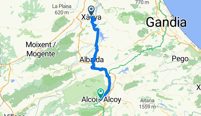
XATIVA - ALCOI POR NACIONAL
A cycling route starting in Xàtiva, Valencia, Spain.
Overview
About this route
Cycling route to cover with panniers in 1 day.
- -:--
- Duration
- 57.3 km
- Distance
- 945 m
- Ascent
- 489 m
- Descent
- ---
- Avg. speed
- ---
- Max. altitude
Continue with Bikemap
Use, edit, or download this cycling route
You would like to ride XATIVA - ALCOI POR NACIONAL or customize it for your own trip? Here is what you can do with this Bikemap route:
Free features
- Save this route as favorite or in collections
- Copy & plan your own version of this route
- Sync your route with Garmin or Wahoo
Premium features
Free trial for 3 days, or one-time payment. More about Bikemap Premium.
- Navigate this route on iOS & Android
- Export a GPX / KML file of this route
- Create your custom printout (try it for free)
- Download this route for offline navigation
Discover more Premium features.
Get Bikemap PremiumFrom our community
Other popular routes starting in Xàtiva
 Xativa - Canals - Navarres - Sumacarcer - Xativa
- Distance
- 71.7 km
- Ascent
- 589 m
- Descent
- 584 m
- Location
- Xàtiva, Valencia, Spain
 Xátiva-Cova Negra-Pantano de Bellús
- Distance
- 36.3 km
- Ascent
- 478 m
- Descent
- 477 m
- Location
- Xàtiva, Valencia, Spain
 Xàtiva-Gandia
- Distance
- 70.6 km
- Ascent
- 754 m
- Descent
- 833 m
- Location
- Xàtiva, Valencia, Spain
 Xativa-Gandia
- Distance
- 85.6 km
- Ascent
- 854 m
- Descent
- 913 m
- Location
- Xàtiva, Valencia, Spain
 From Xàtiva to Almussafes
- Distance
- 42.9 km
- Ascent
- 109 m
- Descent
- 227 m
- Location
- Xàtiva, Valencia, Spain
 xativa por vallada
- Distance
- 120.8 km
- Ascent
- 1,274 m
- Descent
- 1,221 m
- Location
- Xàtiva, Valencia, Spain
 XATIVA - ALCOI POR NACIONAL
- Distance
- 57.3 km
- Ascent
- 945 m
- Descent
- 489 m
- Location
- Xàtiva, Valencia, Spain
 castell Xativa
- Distance
- 2 km
- Ascent
- 193 m
- Descent
- 75 m
- Location
- Xàtiva, Valencia, Spain
Open it in the app