
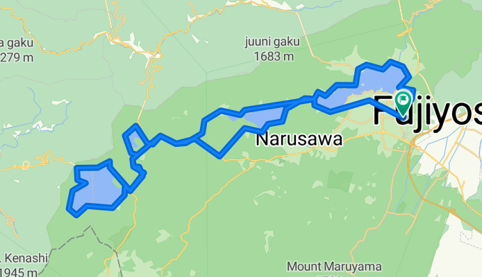
2011-08-11環富士四湖
A cycling route starting in Fujikawaguchiko, Yamanashi, Japan.
Overview
About this route
- -:--
- Duration
- 64.5 km
- Distance
- 490 m
- Ascent
- 493 m
- Descent
- ---
- Avg. speed
- ---
- Max. altitude

Continue with Bikemap
Use, edit, or download this cycling route
You would like to ride 2011-08-11環富士四湖 or customize it for your own trip? Here is what you can do with this Bikemap route:
Free features
- Save this route as favorite or in collections
- Copy & plan your own version of this route
- Sync your route with Garmin or Wahoo
Premium features
Free trial for 3 days, or one-time payment. More about Bikemap Premium.
- Navigate this route on iOS & Android
- Export a GPX / KML file of this route
- Create your custom printout (try it for free)
- Download this route for offline navigation
Discover more Premium features.
Get Bikemap PremiumFrom our community
Other popular routes starting in Fujikawaguchiko
 Day 10:Kawaguchiko-Izunagaoka
- Distance
- 99.4 km
- Ascent
- 1,936 m
- Descent
- 2,768 m
- Location
- Fujikawaguchiko, Yamanashi, Japan
 🇯🇵 JPN D12b - YOKOHAMA
- Distance
- 210.2 km
- Ascent
- 489 m
- Descent
- 1,330 m
- Location
- Fujikawaguchiko, Yamanashi, Japan
 20181028fuji-2
- Distance
- 68.2 km
- Ascent
- 512 m
- Descent
- 508 m
- Location
- Fujikawaguchiko, Yamanashi, Japan
 2011-08-11環富士四湖
- Distance
- 64.5 km
- Ascent
- 490 m
- Descent
- 493 m
- Location
- Fujikawaguchiko, Yamanashi, Japan
 Yamanaka Lake to Fuji river
- Distance
- 149.5 km
- Ascent
- 2,518 m
- Descent
- 3,222 m
- Location
- Fujikawaguchiko, Yamanashi, Japan
 富士山 伊豆 熱海 伊東
- Distance
- 100.7 km
- Ascent
- 856 m
- Descent
- 1,696 m
- Location
- Fujikawaguchiko, Yamanashi, Japan
 20241027_奥富士ロングライド
- Distance
- 55 km
- Ascent
- 1,784 m
- Descent
- 1,785 m
- Location
- Fujikawaguchiko, Yamanashi, Japan
 3624, 船津, 富士河口湖町 nach 鳴沢, 鳴沢村
- Distance
- 9.8 km
- Ascent
- 162 m
- Descent
- 30 m
- Location
- Fujikawaguchiko, Yamanashi, Japan
Open it in the app