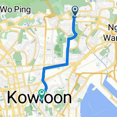
爆肝一日雙塔行
A cycling route starting in Wong Tai Sin, Wong Tai Sin, Hong Kong.
Overview
About this route
- -:--
- Duration
- 11.5 km
- Distance
- 216 m
- Ascent
- 409 m
- Descent
- ---
- Avg. speed
- ---
- Avg. speed
Route quality
Waytypes & surfaces along the route
Waytypes
Busy road
7.7 km
(67 %)
Cycleway
2.2 km
(19 %)
Surfaces
Paved
10.6 km
(92 %)
Asphalt
7 km
(61 %)
Concrete
3.6 km
(31 %)
Undefined
0.9 km
(8 %)
Route highlights
Points of interest along the route
Point of interest after 5.5 km
Point of interest after 6.8 km
Continue with Bikemap
Use, edit, or download this cycling route
You would like to ride 爆肝一日雙塔行 or customize it for your own trip? Here is what you can do with this Bikemap route:
Free features
- Save this route as favorite or in collections
- Copy & plan your own version of this route
- Sync your route with Garmin or Wahoo
Premium features
Free trial for 3 days, or one-time payment. More about Bikemap Premium.
- Navigate this route on iOS & Android
- Export a GPX / KML file of this route
- Create your custom printout (try it for free)
- Download this route for offline navigation
Discover more Premium features.
Get Bikemap PremiumFrom our community
Other popular routes starting in Wong Tai Sin
- Route to 6 Salisbury Road, Tsim Sha Tsui
- Distance
- 6 km
- Ascent
- 161 m
- Descent
- 194 m
- Location
- Wong Tai Sin, Wong Tai Sin, Hong Kong
- Tsz Wan Shan to Tsuen Wan
- Distance
- 19.4 km
- Ascent
- 573 m
- Descent
- 667 m
- Location
- Wong Tai Sin, Wong Tai Sin, Hong Kong
- 爆肝一日雙塔行
- Distance
- 11.5 km
- Ascent
- 216 m
- Descent
- 409 m
- Location
- Wong Tai Sin, Wong Tai Sin, Hong Kong
- 九龍坳山落山
- Distance
- 5.8 km
- Ascent
- 28 m
- Descent
- 395 m
- Location
- Wong Tai Sin, Wong Tai Sin, Hong Kong
- Lengthy bike tour through O Pui Village
- Distance
- 33.9 km
- Ascent
- 350 m
- Descent
- 371 m
- Location
- Wong Tai Sin, Wong Tai Sin, Hong Kong
- Quick bike tour from (null) to (null)
- Distance
- 0.1 km
- Ascent
- 0 m
- Descent
- 0 m
- Location
- Wong Tai Sin, Wong Tai Sin, Hong Kong
- 彩虹 - 荃灣 CLONED FROM ROUTE 956141
- Distance
- 18.4 km
- Ascent
- 289 m
- Descent
- 303 m
- Location
- Wong Tai Sin, Wong Tai Sin, Hong Kong
- KLN Tong -> Cargo Pier #8 -> Kwai Fong
- Distance
- 32.5 km
- Ascent
- 168 m
- Descent
- 189 m
- Location
- Wong Tai Sin, Wong Tai Sin, Hong Kong
Open it in the app