

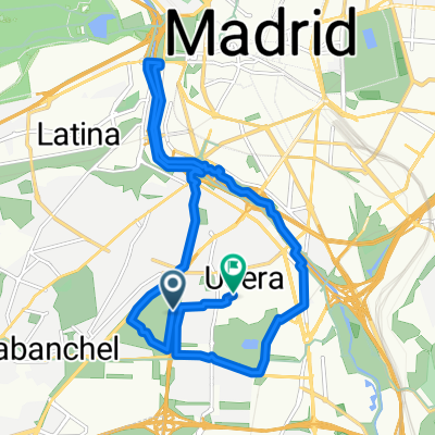
Plaza Elíptica - Vía verde Móstoles (antigua vía Madrid-Almorox)
A cycling route starting in Carabanchel, Madrid, Spain.
Overview
About this route
Route from the vicinity of Plaza Elíptica to the beginning of the greenway of Móstoles near the El Soto park. The first part to Alcorcón runs mainly along bike lanes (Madrid) and parks and paths (Leganés). The first part of Alcorcón to the Renfe station of central Alcorcón is through the streets, and from there to almost the end of the route along the bike lane that connects Móstoles and Alcorcón.
- -:--
- Duration
- 23.5 km
- Distance
- 196 m
- Ascent
- 172 m
- Descent
- ---
- Avg. speed
- ---
- Max. altitude

Route highlights
Points of interest along the route
\"")
Point of interest after 23.5 km
Continue with Bikemap
Use, edit, or download this cycling route
You would like to ride Plaza Elíptica - Vía verde Móstoles (antigua vía Madrid-Almorox) or customize it for your own trip? Here is what you can do with this Bikemap route:
Free features
- Save this route as favorite or in collections
- Copy & plan your own version of this route
- Sync your route with Garmin or Wahoo
Premium features
Free trial for 3 days, or one-time payment. More about Bikemap Premium.
- Navigate this route on iOS & Android
- Export a GPX / KML file of this route
- Create your custom printout (try it for free)
- Download this route for offline navigation
Discover more Premium features.
Get Bikemap PremiumFrom our community
Other popular routes starting in Carabanchel
 Carabanchel, Madrid a Calle del Teniente Compaired, Madrid
- Distance
- 16.9 km
- Ascent
- 108 m
- Descent
- 107 m
- Location
- Carabanchel, Madrid, Spain
 Vuelta a la Casa de Campo
- Distance
- 19.7 km
- Ascent
- 149 m
- Descent
- 172 m
- Location
- Carabanchel, Madrid, Spain
 Madrid-Santiago
- Distance
- 752.8 km
- Ascent
- 2,936 m
- Descent
- 3,312 m
- Location
- Carabanchel, Madrid, Spain
 15-05-2011 hasta cerca valpalomero
- Distance
- 39.7 km
- Ascent
- 275 m
- Descent
- 206 m
- Location
- Carabanchel, Madrid, Spain
 Anillo Verde Ciclista
- Distance
- 34 km
- Ascent
- 243 m
- Descent
- 241 m
- Location
- Carabanchel, Madrid, Spain
 Madrid - San Martín de la Vega - Arganda por La Nueva y el Pico del Águila - Velilla de San Antonio - Madrid por Cristo Rivas
- Distance
- 87.1 km
- Ascent
- 604 m
- Descent
- 604 m
- Location
- Carabanchel, Madrid, Spain
 Ruta tranquila en Alcorcón
- Distance
- 17.8 km
- Ascent
- 203 m
- Descent
- 80 m
- Location
- Carabanchel, Madrid, Spain
 Recorriendo la orilla del Manzanares
- Distance
- 57.9 km
- Ascent
- 238 m
- Descent
- 251 m
- Location
- Carabanchel, Madrid, Spain
Open it in the app