

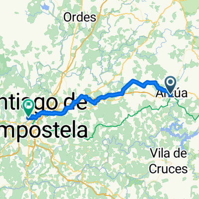
32.Stiago Ende Renner
A cycling route starting in Arzúa, Galicia, Spain.
Overview
About this route
- -:--
- Duration
- 42.2 km
- Distance
- 624 m
- Ascent
- 775 m
- Descent
- ---
- Avg. speed
- 409 m
- Max. altitude

Continue with Bikemap
Use, edit, or download this cycling route
You would like to ride 32.Stiago Ende Renner or customize it for your own trip? Here is what you can do with this Bikemap route:
Free features
- Save this route as favorite or in collections
- Copy & plan your own version of this route
- Sync your route with Garmin or Wahoo
Premium features
Free trial for 3 days, or one-time payment. More about Bikemap Premium.
- Navigate this route on iOS & Android
- Export a GPX / KML file of this route
- Create your custom printout (try it for free)
- Download this route for offline navigation
Discover more Premium features.
Get Bikemap PremiumFrom our community
Other popular routes starting in Arzúa
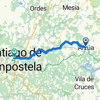
 BHC Arzúa - Santiago de Compostela 50 km
- Distance
- 47.4 km
- Ascent
- 945 m
- Descent
- 1,054 m
- Location
- Arzúa, Galicia, Spain
 32.Stiago Ende Renner
- Distance
- 42.2 km
- Ascent
- 624 m
- Descent
- 775 m
- Location
- Arzúa, Galicia, Spain
 Santiso - Santiago di Compostela
- Distance
- 44.2 km
- Ascent
- 812 m
- Descent
- 950 m
- Location
- Arzúa, Galicia, Spain
 2007 - Auf dem Jakobsweg - 03. Tag - Arzúa - Santiago de Compostela
- Distance
- 41 km
- Ascent
- 391 m
- Descent
- 520 m
- Location
- Arzúa, Galicia, Spain
 SdC_2024_Tag7_Arzúa nach Monte do Gozo
- Distance
- 27.5 km
- Ascent
- 30 m
- Descent
- 70 m
- Location
- Arzúa, Galicia, Spain
 Arzua Santiago
- Distance
- 39.6 km
- Ascent
- 439 m
- Descent
- 568 m
- Location
- Arzúa, Galicia, Spain
 Route to Santiago de Compostela. Casco Historico
- Distance
- 41.8 km
- Ascent
- 797 m
- Descent
- 885 m
- Location
- Arzúa, Galicia, Spain
 Rúa Camiño do N, Arzúa to Santiago de Compostela
- Distance
- 45.5 km
- Ascent
- 844 m
- Descent
- 1,015 m
- Location
- Arzúa, Galicia, Spain
Open it in the app