

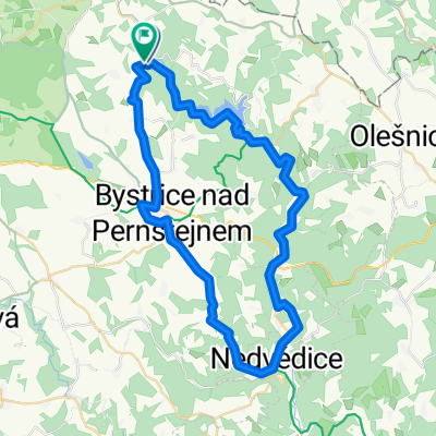
na Lucký vrch
A cycling route starting in Jimramov, Kraj Vysočina, Czechia.
Overview
About this route
- -:--
- Duration
- 7.8 km
- Distance
- 216 m
- Ascent
- 72 m
- Descent
- ---
- Avg. speed
- ---
- Max. altitude

Route quality
Waytypes & surfaces along the route
Waytypes
Track
1.9 km
(24 %)
Quiet road
0.8 km
(10 %)
Undefined
5.1 km
(66 %)
Surfaces
Paved
0.2 km
(2 %)
Unpaved
1.8 km
(23 %)
Ground
1.5 km
(19 %)
Gravel
0.3 km
(4 %)
Route highlights
Points of interest along the route
Point of interest after 0 km
Continue with Bikemap
Use, edit, or download this cycling route
You would like to ride na Lucký vrch or customize it for your own trip? Here is what you can do with this Bikemap route:
Free features
- Save this route as favorite or in collections
- Copy & plan your own version of this route
- Sync your route with Garmin or Wahoo
Premium features
Free trial for 3 days, or one-time payment. More about Bikemap Premium.
- Navigate this route on iOS & Android
- Export a GPX / KML file of this route
- Create your custom printout (try it for free)
- Download this route for offline navigation
Discover more Premium features.
Get Bikemap PremiumFrom our community
Other popular routes starting in Jimramov
 okolo Sedliště MTB
- Distance
- 26.1 km
- Ascent
- 626 m
- Descent
- 625 m
- Location
- Jimramov, Kraj Vysočina, Czechia
 Daňkovice-Sádek-Svratouch-Fryšava-Bohdalec-Daňkovice
- Distance
- 63.8 km
- Ascent
- 1,011 m
- Descent
- 1,011 m
- Location
- Jimramov, Kraj Vysočina, Czechia
 Jimramov - Korouhev - Polička - Bystré
- Distance
- 46.6 km
- Ascent
- 719 m
- Descent
- 719 m
- Location
- Jimramov, Kraj Vysočina, Czechia
 Dalečín 2
- Distance
- 49.7 km
- Ascent
- 1,289 m
- Descent
- 1,290 m
- Location
- Jimramov, Kraj Vysočina, Czechia
 Tour de Vysočina 2018
- Distance
- 103.3 km
- Ascent
- 1,108 m
- Descent
- 1,109 m
- Location
- Jimramov, Kraj Vysočina, Czechia
 Dalečín BudKa Zubštejn
- Distance
- 29.9 km
- Ascent
- 554 m
- Descent
- 559 m
- Location
- Jimramov, Kraj Vysočina, Czechia
 Sněžné - Toulcovy Maštale
- Distance
- 64.9 km
- Ascent
- 775 m
- Descent
- 774 m
- Location
- Jimramov, Kraj Vysočina, Czechia
 Konikovske polesi
- Distance
- 18.1 km
- Ascent
- 307 m
- Descent
- 305 m
- Location
- Jimramov, Kraj Vysočina, Czechia
Open it in the app