

DAY TWO (a) Savigny-sous-Faye - Monts-sur-Guesnes
A cycling route starting in Lencloître, Nouvelle-Aquitaine, France.
Overview
About this route
Day Two - Morning
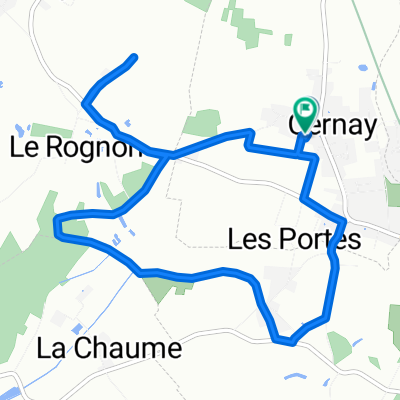
Camping Municipal Les Iris, Savigny-sous-Faye - Bar Restaurant Le Cheval Blanc, Monts-sur-Guesnes
The route rejoins the Voie Verte which increasingly becomes more and more like a rough track in many places. A gradual incline adds to this slow progress. The last few kilometres involve a short, steep climb on a country road into the small village of Monts-sur-Guesnes. The restored Château of Monts-sur-Guesnes, if times allows, is worthy of a visit. Whilst a lunch in the Bar Restaurant Le Cheval Blanc is both inexpensive and tasty.
- 56 min
- Duration
- 12 km
- Distance
- 78 m
- Ascent
- 63 m
- Descent
- 12.9 km/h
- Avg. speed
- 125 m
- Max. altitude

Route quality
Waytypes & surfaces along the route
Waytypes
Cycleway
9.4 km
(79 %)
Quiet road
1.8 km
(15 %)
Road
0.7 km
(6 %)
Surfaces
Paved
1.6 km
(14 %)
Unpaved
7.8 km
(65 %)
Gravel
7.8 km
(65 %)
Asphalt
1.6 km
(14 %)
Undefined
2.6 km
(21 %)
Continue with Bikemap
Use, edit, or download this cycling route
You would like to ride DAY TWO (a) Savigny-sous-Faye - Monts-sur-Guesnes or customize it for your own trip? Here is what you can do with this Bikemap route:
Free features
- Save this route as favorite or in collections
- Copy & plan your own version of this route
- Sync your route with Garmin or Wahoo
Premium features
Free trial for 3 days, or one-time payment. More about Bikemap Premium.
- Navigate this route on iOS & Android
- Export a GPX / KML file of this route
- Create your custom printout (try it for free)
- Download this route for offline navigation
Discover more Premium features.
Get Bikemap PremiumFrom our community
Other popular routes starting in Lencloître
 4 Rue du Lavoir, Savigny-sous-Faye to 5 Rue de la Champbaudière, Monts-sur-Guesnes
- Distance
- 11.9 km
- Ascent
- 78 m
- Descent
- 63 m
- Location
- Lencloître, Nouvelle-Aquitaine, France
 De Chemin des Coutures à Chemin des Coutures 1er tour
- Distance
- 8.8 km
- Ascent
- 50 m
- Descent
- 99 m
- Location
- Lencloître, Nouvelle-Aquitaine, France
 D7, Berthegon to 99–103 Boulevard de Blossac, Châtellerault
- Distance
- 32.2 km
- Ascent
- 161 m
- Descent
- 206 m
- Location
- Lencloître, Nouvelle-Aquitaine, France
 course UFOLEP BERTHEGON
- Distance
- 10.3 km
- Ascent
- 84 m
- Descent
- 86 m
- Location
- Lencloître, Nouvelle-Aquitaine, France
 DOUSSAY
- Distance
- 9.6 km
- Ascent
- 64 m
- Descent
- 64 m
- Location
- Lencloître, Nouvelle-Aquitaine, France
 De 11 Rue de la Lande, Lencloître à 11 Rue de la Lande, Lencloître
- Distance
- 9.5 km
- Ascent
- 54 m
- Descent
- 48 m
- Location
- Lencloître, Nouvelle-Aquitaine, France
 De 16 Route de Poitiers, Lencloître à D757, Thurageau
- Distance
- 1.9 km
- Ascent
- 3 m
- Descent
- 6 m
- Location
- Lencloître, Nouvelle-Aquitaine, France
 Voie Sylvain Chavanel, Lencloître to 8 Rue du Lavoir, Savigny-sous-Faye
- Distance
- 6.8 km
- Ascent
- 44 m
- Descent
- 16 m
- Location
- Lencloître, Nouvelle-Aquitaine, France
Open it in the app