

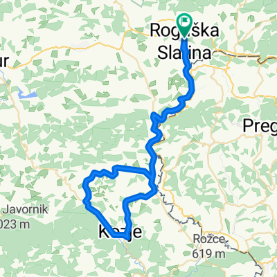
Rogaška - Kozje
A cycling route starting in Rogaška Slatina, Občina Rogaška Slatina, Slovenia.
Overview
About this route
- -:--
- Duration
- 31.6 km
- Distance
- 397 m
- Ascent
- 338 m
- Descent
- ---
- Avg. speed
- 402 m
- Max. altitude

Route quality
Waytypes & surfaces along the route
Waytypes
Cycleway
19.3 km
(61 %)
Road
7.3 km
(23 %)
Surfaces
Paved
15.8 km
(50 %)
Asphalt
15.8 km
(50 %)
Undefined
15.8 km
(50 %)
Route highlights
Points of interest along the route
Point of interest after 3.5 km
Bobrov center Kavica za dober štart
Point of interest after 11.6 km
Sladoled
Point of interest after 20.9 km
Banovina Osvežitev po vzponu
Point of interest after 27.5 km
Pilšanj - pranger Kdor je pešačil v hrib se naj za kazen priklene in slika :)
Point of interest after 31.6 km
Kozjanski dvor Obnova kalorij ali pa vsaj kaj sladkega tudi paše
Continue with Bikemap
Use, edit, or download this cycling route
You would like to ride Rogaška - Kozje or customize it for your own trip? Here is what you can do with this Bikemap route:
Free features
- Save this route as favorite or in collections
- Copy & plan your own version of this route
- Sync your route with Garmin or Wahoo
Premium features
Free trial for 3 days, or one-time payment. More about Bikemap Premium.
- Navigate this route on iOS & Android
- Export a GPX / KML file of this route
- Create your custom printout (try it for free)
- Download this route for offline navigation
Discover more Premium features.
Get Bikemap PremiumFrom our community
Other popular routes starting in Rogaška Slatina
 Maraton Rogaška Slatina
- Distance
- 61 km
- Ascent
- 409 m
- Descent
- 409 m
- Location
- Rogaška Slatina, Občina Rogaška Slatina, Slovenia
 Rogaška - Kozje
- Distance
- 31.6 km
- Ascent
- 397 m
- Descent
- 338 m
- Location
- Rogaška Slatina, Občina Rogaška Slatina, Slovenia
 STKP 27adj: Planinski dom na Boču – Gorišnica
- Distance
- 47.5 km
- Ascent
- 1,707 m
- Descent
- 1,707 m
- Location
- Rogaška Slatina, Občina Rogaška Slatina, Slovenia
 Hajnsko Boč via Vonarje
- Distance
- 43.7 km
- Ascent
- 670 m
- Descent
- 670 m
- Location
- Rogaška Slatina, Občina Rogaška Slatina, Slovenia
 Zgornja Kostrivnica to Zgornja Kostrivnica
- Distance
- 22.5 km
- Ascent
- 0 m
- Descent
- 0 m
- Location
- Rogaška Slatina, Občina Rogaška Slatina, Slovenia
 rogaška-boč-makole-podboč-boč-rogaška
- Distance
- 41.2 km
- Ascent
- 1,007 m
- Descent
- 935 m
- Location
- Rogaška Slatina, Občina Rogaška Slatina, Slovenia
 Rogaška-Šmarje pri Jelšah-Rogaška
- Distance
- 54.2 km
- Ascent
- 413 m
- Descent
- 412 m
- Location
- Rogaška Slatina, Občina Rogaška Slatina, Slovenia
 Hajnsko Ptuj
- Distance
- 96.5 km
- Ascent
- 550 m
- Descent
- 550 m
- Location
- Rogaška Slatina, Občina Rogaška Slatina, Slovenia
Open it in the app