Elizabeth East to Hilton South Australia
A cycling route starting in Elizabeth, South Australia, Australia.
Overview
About this route
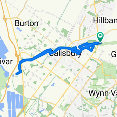
I use this as my commute route. I could use Salisbury Hwy but there is no "safe" connection with Churchill Rd North from the Port Wakefield Rd Intersecion. Many semi trailers here.
Â
The portion of the route that runs paralell with Parafield Airport is a shared path. It's unlit at night and trees are encrouching. The surface if bitumanised however at the south end near the Mawson Lakes Interchange there is gravel and a steel framed wooden slat bridge to cross.
Â
The lights at the corner of Port Rd and James Congdon Drive are bike friendly with buttons and safe refuge areas.
Â
The route can continue on to Adelaide airport, West Beach and either left onto Tapleys Hill Rd to Glenelg or to the coast then right to Semaphore and other suburbs.
- -:--
- Duration
- 30.5 km
- Distance
- 48 m
- Ascent
- 91 m
- Descent
- ---
- Avg. speed
- ---
- Avg. speed
Continue with Bikemap
Use, edit, or download this cycling route
You would like to ride Elizabeth East to Hilton South Australia or customize it for your own trip? Here is what you can do with this Bikemap route:
Free features
- Save this route as favorite or in collections
- Copy & plan your own version of this route
- Sync your route with Garmin or Wahoo
Premium features
Free trial for 3 days, or one-time payment. More about Bikemap Premium.
- Navigate this route on iOS & Android
- Export a GPX / KML file of this route
- Create your custom printout (try it for free)
- Download this route for offline navigation
Discover more Premium features.
Get Bikemap PremiumFrom our community
Other popular routes starting in Elizabeth
- Star Cycles Inglewood-COP-Kersbrook
- Distance
- 64 km
- Ascent
- 717 m
- Descent
- 717 m
- Location
- Elizabeth, South Australia, Australia
- Angaston to Handorf
- Distance
- 234.1 km
- Ascent
- 1,334 m
- Descent
- 1,333 m
- Location
- Elizabeth, South Australia, Australia
- Elizabeth - Nuriootpa
- Distance
- 134.8 km
- Ascent
- 960 m
- Descent
- 722 m
- Location
- Elizabeth, South Australia, Australia
- Little Para River Trl, Salisbury Park to 12 Main St, Mawson Lakes
- Distance
- 12.3 km
- Ascent
- 30 m
- Descent
- 70 m
- Location
- Elizabeth, South Australia, Australia
- Star Cycles - Sandy Creek - hillier rd
- Distance
- 59.8 km
- Ascent
- 196 m
- Descent
- 196 m
- Location
- Elizabeth, South Australia, Australia
- Yorktown Road 32, Elizabeth East to McCormack Crescent 50, Salisbury North
- Distance
- 20.9 km
- Ascent
- 255 m
- Descent
- 285 m
- Location
- Elizabeth, South Australia, Australia
- Star Cycles - Ansteys Hill
- Distance
- 58.8 km
- Ascent
- 536 m
- Descent
- 542 m
- Location
- Elizabeth, South Australia, Australia
- Elizabeth East to Hilton South Australia
- Distance
- 30.5 km
- Ascent
- 48 m
- Descent
- 91 m
- Location
- Elizabeth, South Australia, Australia
Open it in the app