

Schwäbische Alb Schwarzwald
SAS-0103 Gruibingen bis Bad Urach
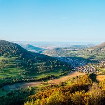
A cycling route starting in Gruibingen, Baden-Wurttemberg, Germany.
Overview
About this route
Author: Schwäbische Alb Tourismusverband e.V. - Author: Schwäbische Alb Tourismusverband e.V.
- -:--
- Duration
- 51.3 km
- Distance
- 1,388 m
- Ascent
- 1,606 m
- Descent
- ---
- Avg. speed
- 805 m
- Max. altitude

Part of
Schwäbische Alb Schwarzwald
7 stages
Route quality
Waytypes & surfaces along the route
Waytypes
Track
40 km
(78 %)
Quiet road
5.6 km
(11 %)
Surfaces
Paved
22.1 km
(43 %)
Unpaved
26.2 km
(51 %)
Asphalt
19 km
(37 %)
Gravel
15.4 km
(30 %)
Continue with Bikemap
Use, edit, or download this cycling route
You would like to ride SAS-0103 Gruibingen bis Bad Urach or customize it for your own trip? Here is what you can do with this Bikemap route:
Free features
- Save this route as favorite or in collections
- Copy & plan your own version of this route
- Sync your route with Garmin or Wahoo
Premium features
Free trial for 3 days, or one-time payment. More about Bikemap Premium.
- Navigate this route on iOS & Android
- Export a GPX / KML file of this route
- Create your custom printout (try it for free)
- Download this route for offline navigation
Discover more Premium features.
Get Bikemap PremiumFrom our community
Other popular routes starting in Gruibingen
 SAS-0103 Gruibingen bis Bad Urach
- Distance
- 51.3 km
- Ascent
- 1,388 m
- Descent
- 1,606 m
- Location
- Gruibingen, Baden-Wurttemberg, Germany
 Alptraufmarathon (Gruibingen)
- Distance
- 59.3 km
- Ascent
- 1,108 m
- Descent
- 1,107 m
- Location
- Gruibingen, Baden-Wurttemberg, Germany
 Gruibingen - Boll - Dürnau - Gammelshausen - Gruibingen
- Distance
- 17.2 km
- Ascent
- 334 m
- Descent
- 334 m
- Location
- Gruibingen, Baden-Wurttemberg, Germany
 Buch - Bossler
- Distance
- 13.6 km
- Ascent
- 178 m
- Descent
- 195 m
- Location
- Gruibingen, Baden-Wurttemberg, Germany
 Marathon-G Test
- Distance
- 92.7 km
- Ascent
- 1,693 m
- Descent
- 1,693 m
- Location
- Gruibingen, Baden-Wurttemberg, Germany
 Albtraufmarathon kurz
- Distance
- 59.5 km
- Ascent
- 1,103 m
- Descent
- 1,102 m
- Location
- Gruibingen, Baden-Wurttemberg, Germany
 Maierhofstraße 17/1, Gruibingen nach Maierhofstraße 17, Gruibingen
- Distance
- 15.5 km
- Ascent
- 310 m
- Descent
- 310 m
- Location
- Gruibingen, Baden-Wurttemberg, Germany
 Sickenbühl-Reisenstein-Bahnhöle -Neidlingen Reisenstein-Sickenbühl
- Distance
- 24.2 km
- Ascent
- 673 m
- Descent
- 660 m
- Location
- Gruibingen, Baden-Wurttemberg, Germany
Open it in the app