

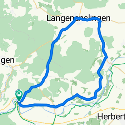
Scheer 33,3-530m
A cycling route starting in Scheer, Baden-Wurttemberg, Germany.
Overview
About this route
hilly
- -:--
- Duration
- 33.3 km
- Distance
- 607 m
- Ascent
- 606 m
- Descent
- ---
- Avg. speed
- 787 m
- Max. altitude

Route quality
Waytypes & surfaces along the route
Waytypes
Road
14.4 km
(43 %)
Quiet road
10.2 km
(31 %)
Surfaces
Paved
10.3 km
(31 %)
Unpaved
0.5 km
(1 %)
Asphalt
10 km
(30 %)
Unpaved (undefined)
0.5 km
(1 %)
Continue with Bikemap
Use, edit, or download this cycling route
You would like to ride Scheer 33,3-530m or customize it for your own trip? Here is what you can do with this Bikemap route:
Free features
- Save this route as favorite or in collections
- Copy & plan your own version of this route
- Sync your route with Garmin or Wahoo
Premium features
Free trial for 3 days, or one-time payment. More about Bikemap Premium.
- Navigate this route on iOS & Android
- Export a GPX / KML file of this route
- Create your custom printout (try it for free)
- Download this route for offline navigation
Discover more Premium features.
Get Bikemap PremiumFrom our community
Other popular routes starting in Scheer
 geschäft
- Distance
- 11.1 km
- Ascent
- 254 m
- Descent
- 256 m
- Location
- Scheer, Baden-Wurttemberg, Germany
 De Bahnhofstraße 21, Scheer à Hauptstraße 10, Ehingen (Donau)
- Distance
- 67.5 km
- Ascent
- 371 m
- Descent
- 425 m
- Location
- Scheer, Baden-Wurttemberg, Germany
 Ertingen
- Distance
- 35.2 km
- Ascent
- 238 m
- Descent
- 250 m
- Location
- Scheer, Baden-Wurttemberg, Germany
 1b Scheer Ulm
- Distance
- 97.2 km
- Ascent
- 136 m
- Descent
- 229 m
- Location
- Scheer, Baden-Wurttemberg, Germany
 ölkofen
- Distance
- 12.5 km
- Ascent
- 141 m
- Descent
- 168 m
- Location
- Scheer, Baden-Wurttemberg, Germany
 4. Tag Scheer - tuttlingen
- Distance
- 66.7 km
- Ascent
- 259 m
- Descent
- 174 m
- Location
- Scheer, Baden-Wurttemberg, Germany
 Rute Heudorf Willingen Scheer Heudorf
- Distance
- 13.6 km
- Ascent
- 257 m
- Descent
- 266 m
- Location
- Scheer, Baden-Wurttemberg, Germany
 30km Sigmaringendorf Donau
- Distance
- 30.5 km
- Ascent
- 280 m
- Descent
- 262 m
- Location
- Scheer, Baden-Wurttemberg, Germany
Open it in the app