Mühlentur
- 16.9 km
- 357 m
- 320 m
- Wegberg, North Rhine-Westphalia, Germany
A cycling route starting in Wegberg, North Rhine-Westphalia, Germany.
Overview
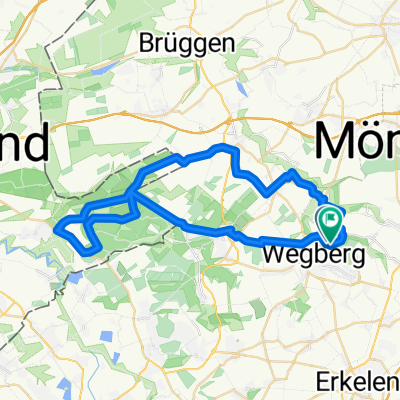
The Mill Route lives up to its name. It runs along a variety of different mills, all of which have significantly shaped the history of the town of Wegberg. The starting point of the Mill Route is the Wegberger Mühle from the year 1505. It is open for visits and, besides a café, also offers a cultural taste of the upcoming tour. Over more than 42 kilometers through a gently hilly and woodland landscape, many of the formerly 25 water mills in the city area of Wegberg reveal their full beauty.
We start our tour at the Wegberger Mühle, also known as Ramachers Mühle. It is a former oil and grain mill, centrally located between the castle and the church on the Schwalm. Milling operations were only discontinued in 1960. Today, the mill serves cultural purposes.
Along the Beeckbach stream, we reach the Ophover Mühle with a pond. It probably dates back to the 14th century and was a grain mill with a undershot waterwheel. From 1867 it was a water and steam mill, thus operating with a steam engine in addition. It was the last mill in Wegberg still operating with water power. It was closed in 1965. Ulrike and Holger Hendricks revived the Ophover Mühle around fifteen years ago with their gastronomy business, turning it into a historically significant and much-visited attraction.
Following the Beeckbach stream, we ride through Gerichhausen to Beeck. There we cross the border ring towards Kipshoven. Further along, the tour leads us through fields to Gripekoven and then to Ellinghoven. Behind Ellinghoven, we cross the railway line 'Iron Rhine' and head into the Beeckerwald forest. Via forest paths we reach the Holtmühle, an oil and grain mill from the 14th century that was in operation until 1954 and was then converted into an excursion restaurant. Even today, one can sit comfortably on the sunny terrace by the mill pond.
From here, the Mill Route takes us along Hospital Street to the Buschmühle, the only mill situated on the left side of the mill stream. Since the 18th century, the mill has operated as an oil mill. After the end of World War II, it was converted from water to electric power and finally closed in 1953. The grinding equipment for grain and oil is completely preserved and functioning since its restoration.
Close by is the Schrofmühle from the 16th century with an attached small mill museum. The Schrofmühle is the only fully functional grain and oil mill remaining in Rhineland.
From the Schrofmühle, we continue to the Molzmühle at the mouth of the Schwalm into the mill stream. It also operated for centuries as a grain and oil mill, for up to 16 hours a day. In 1930, milling operations ceased, and since then, it has functioned as a restaurant with a quaint beer garden.
Along the Schwalm, the route now runs directly along the bank of the stream, before turning left towards Tetelrath and further to Merbeck. Shortly thereafter, we reach the Rakyweiher at Dalheim. The Rakyweiher is a beautifully located lake at Alde Berg.
Shortly after Dalheim, we encounter the Dalheimer Mühle at Rothenbach. It is already mentioned in a parchment purchase deed from 1231 and may thus be the oldest water mill between Maas and Rhine. Until 1802, the mill served as a source of income for the nearby Cistercian convent "Himmelstal."
From the Dalheimer Mühle, we pass by the monastery courtyard back to Dalheim and from there continue towards Wildenrath. From Wildenrath, the tour passes the Wegberger Oval (Siemens testing ground for rail vehicles) to Tüschenbroich. At the Tüschenbroicher Pond, in addition to the castle, are the two interesting Tüschenbroicher Mills (oil and grain mill).
Very close by is the Bockenmühle. A bit further is the Bischofsmühle. The Bischofsmühle has just been recently restored and a new fish ladder has been built.
created this 2 years ago


Route quality
Quiet road
17.2 km
(40 %)
Track
10.8 km
(25 %)
Paved
32.7 km
(76 %)
Unpaved
8.6 km
(20 %)
Asphalt
31.4 km
(73 %)
Gravel
4.7 km
(11 %)
Continue with Bikemap
You would like to ride NR914: Wegberger Mühlentour or customize it for your own trip? Here is what you can do with this Bikemap route:
Free trial for 3 days, or one-time payment. More about Bikemap Premium.
Discover more Premium features.
Get Bikemap PremiumFrom our community
Open it in the app