
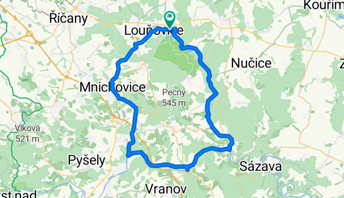
Vyžlovka-Senohraby-Chocerady: malý okruh
A cycling route starting in Mukařov, Central Bohemia, Czechia.
Overview
About this route
- -:--
- Duration
- 44.1 km
- Distance
- 388 m
- Ascent
- 379 m
- Descent
- ---
- Avg. speed
- ---
- Max. altitude
Route highlights
Points of interest along the route
Point of interest after 9.1 km
Kostel v Mnichovicích
Point of interest after 16.1 km
Hláska - zbytky hradu
Point of interest after 16.1 km
občerstvení - stánek u přívozu
Point of interest after 23.3 km
hospoda - občerstvení
Point of interest after 28.5 km
hospoda na Marjáně
Continue with Bikemap
Use, edit, or download this cycling route
You would like to ride Vyžlovka-Senohraby-Chocerady: malý okruh or customize it for your own trip? Here is what you can do with this Bikemap route:
Free features
- Save this route as favorite or in collections
- Copy & plan your own version of this route
- Sync your route with Garmin or Wahoo
Premium features
Free trial for 3 days, or one-time payment. More about Bikemap Premium.
- Navigate this route on iOS & Android
- Export a GPX / KML file of this route
- Create your custom printout (try it for free)
- Download this route for offline navigation
Discover more Premium features.
Get Bikemap PremiumFrom our community
Other popular routes starting in Mukařov
 Vyžlovka-Senohraby-Chocerady: malý okruh
- Distance
- 44.1 km
- Ascent
- 388 m
- Descent
- 379 m
- Location
- Mukařov, Central Bohemia, Czechia
 VD Srbin-Mnichovka 45
- Distance
- 46.5 km
- Ascent
- 655 m
- Descent
- 656 m
- Location
- Mukařov, Central Bohemia, Czechia
 0022: Žernovka - Louňovice - Svojetice - Klokočná - Mnichovice
- Distance
- 10.8 km
- Ascent
- 213 m
- Descent
- 238 m
- Location
- Mukařov, Central Bohemia, Czechia
 8173: Tehov – Menčice – Mnichovice
- Distance
- 5.3 km
- Ascent
- 61 m
- Descent
- 168 m
- Location
- Mukařov, Central Bohemia, Czechia
 VD Srbin-Mnichovka 45
- Distance
- 46.4 km
- Ascent
- 662 m
- Descent
- 663 m
- Location
- Mukařov, Central Bohemia, Czechia
 8206: Babice – Doubek – Zahrady
- Distance
- 13.2 km
- Ascent
- 100 m
- Descent
- 265 m
- Location
- Mukařov, Central Bohemia, Czechia
 Školní, Mukařov do Hlavní, Senohraby
- Distance
- 42.6 km
- Ascent
- 453 m
- Descent
- 546 m
- Location
- Mukařov, Central Bohemia, Czechia
 Březí - Týnec nad Vltavou - Dolní Břežany - Průhonice - Březí
- Distance
- 90.2 km
- Ascent
- 668 m
- Descent
- 656 m
- Location
- Mukařov, Central Bohemia, Czechia
Open it in the app