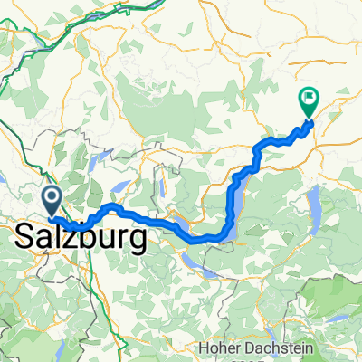
Freilassing-Laufen-Abtsdorf-Schönram
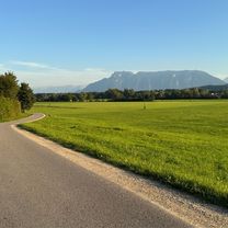
A cycling route starting in Freilassing, Bavaria, Germany.
Overview
About this route
- -:--
- Duration
- 44.3 km
- Distance
- 422 m
- Ascent
- 425 m
- Descent
- ---
- Avg. speed
- 506 m
- Avg. speed
Route quality
Waytypes & surfaces along the route
Waytypes
Quiet road
22.7 km
(51 %)
Track
11.8 km
(27 %)
Surfaces
Paved
19.3 km
(44 %)
Unpaved
11.7 km
(26 %)
Asphalt
19.3 km
(44 %)
Gravel
11.2 km
(25 %)
Continue with Bikemap
Use, edit, or download this cycling route
You would like to ride Freilassing-Laufen-Abtsdorf-Schönram or customize it for your own trip? Here is what you can do with this Bikemap route:
Free features
- Save this route as favorite or in collections
- Copy & plan your own version of this route
- Sync your route with Garmin or Wahoo
Premium features
Free trial for 3 days, or one-time payment. More about Bikemap Premium.
- Navigate this route on iOS & Android
- Export a GPX / KML file of this route
- Create your custom printout (try it for free)
- Download this route for offline navigation
Discover more Premium features.
Get Bikemap PremiumFrom our community
Other popular routes starting in Freilassing
- Freilassing - Stoißeralm
- Distance
- 21.3 km
- Ascent
- 874 m
- Descent
- 41 m
- Location
- Freilassing, Bavaria, Germany
- Waginger See 2
- Distance
- 65.8 km
- Ascent
- 621 m
- Descent
- 626 m
- Location
- Freilassing, Bavaria, Germany
- Freilassing - Winkelmoosalm
- Distance
- 121.1 km
- Ascent
- 1,382 m
- Descent
- 1,382 m
- Location
- Freilassing, Bavaria, Germany
- Ruhige Route
- Distance
- 30.1 km
- Ascent
- 323 m
- Descent
- 357 m
- Location
- Freilassing, Bavaria, Germany
- Schnelle Radrunde durch Freilassing
- Distance
- 5.9 km
- Ascent
- 4 m
- Descent
- 4 m
- Location
- Freilassing, Bavaria, Germany
- Moos -u. Moorweg
- Distance
- 63.4 km
- Ascent
- 379 m
- Descent
- 379 m
- Location
- Freilassing, Bavaria, Germany
- Salzkammergut-Radtour (Tag 1)
- Distance
- 67.5 km
- Ascent
- 473 m
- Descent
- 353 m
- Location
- Freilassing, Bavaria, Germany
- Freilassing - Hochstaufenrunde
- Distance
- 65.5 km
- Ascent
- 836 m
- Descent
- 836 m
- Location
- Freilassing, Bavaria, Germany
Open it in the app