

Monte Prat
A cycling route starting in Spilimbergo, Friuli Venezia Giulia, Italy.
Overview
About this route
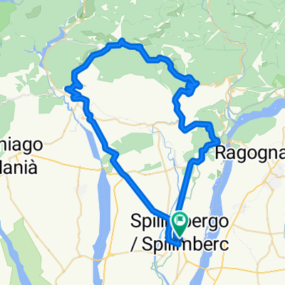
Interesting and little traffic route, until Pinzano there are few cars after it is difficult to find them. The first section is a rise and fall, then we encounter the first demanding slope before Anduins. Then there is a section practically flat until just before Pielungo, which is left on the left. Then we descend towards Cerdevol; after crossing the river, you need to take the little road on the right, which is not very obvious and has no signs. If you pass the streets with the names Reonis and Valentinis, turn back like I did. Now begins the section with the greatest slope, although not remarkable, the biggest difficulty is given by the particularly bad state of the ground with potholes and a lot of debris on the roadway, but here you will hardly find anyone. When you reach a straight section that cuts across the ridge of the mountain, your effort uphill is over. When you reach the fork, turn right and descend towards Monte Prat; after the climb, it will not seem possible to find such a place. The descent, on the other hand, develops on a good two-lane road up to Forgaria and then Flagogna. Here we still have a few climbs left to complete the loop.
- -:--
- Duration
- 67.5 km
- Distance
- 1,001 m
- Ascent
- 999 m
- Descent
- ---
- Avg. speed
- ---
- Max. altitude
Route quality
Waytypes & surfaces along the route
Waytypes
Quiet road
16.9 km
(25 %)
Road
8.1 km
(12 %)
Surfaces
Paved
45.9 km
(68 %)
Asphalt
45.9 km
(68 %)
Undefined
21.6 km
(32 %)
Continue with Bikemap
Use, edit, or download this cycling route
You would like to ride Monte Prat or customize it for your own trip? Here is what you can do with this Bikemap route:
Free features
- Save this route as favorite or in collections
- Copy & plan your own version of this route
- Sync your route with Garmin or Wahoo
Premium features
Free trial for 3 days, or one-time payment. More about Bikemap Premium.
- Navigate this route on iOS & Android
- Export a GPX / KML file of this route
- Create your custom printout (try it for free)
- Download this route for offline navigation
Discover more Premium features.
Get Bikemap PremiumFrom our community
Other popular routes starting in Spilimbergo
 col manzon
- Distance
- 36.6 km
- Ascent
- 544 m
- Descent
- 544 m
- Location
- Spilimbergo, Friuli Venezia Giulia, Italy
 Spilimbergo - Rest-Chianzutan-Spilimbergo
- Distance
- 130.4 km
- Ascent
- 2,239 m
- Descent
- 2,230 m
- Location
- Spilimbergo, Friuli Venezia Giulia, Italy
 training 2022
- Distance
- 162 km
- Ascent
- 3,307 m
- Descent
- 3,307 m
- Location
- Spilimbergo, Friuli Venezia Giulia, Italy
 Via Udine 9, Spilimbergo a Via Udine 9, Spilimbergo
- Distance
- 40.9 km
- Ascent
- 617 m
- Descent
- 620 m
- Location
- Spilimbergo, Friuli Venezia Giulia, Italy
 Monte Prat
- Distance
- 67.5 km
- Ascent
- 1,001 m
- Descent
- 999 m
- Location
- Spilimbergo, Friuli Venezia Giulia, Italy
 Largo Caduti di Nassiriya 1, Spilimbergo a Piazza del Duomo 4, Spilimbergo
- Distance
- 42.4 km
- Ascent
- 652 m
- Descent
- 652 m
- Location
- Spilimbergo, Friuli Venezia Giulia, Italy
 Il sabato delle foglie morte
- Distance
- 63.3 km
- Ascent
- 932 m
- Descent
- 932 m
- Location
- Spilimbergo, Friuli Venezia Giulia, Italy
 Graz-Vieste Etappe 3 (Spilimbergo-Podelta)
- Distance
- 197.8 km
- Ascent
- 116 m
- Descent
- 237 m
- Location
- Spilimbergo, Friuli Venezia Giulia, Italy
Open it in the app