
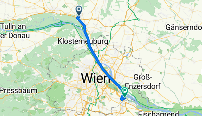
Stockerauer Straße 133, Leobendorf nach Fabianistraße 10, Wien
A cycling route starting in Leobendorf, Lower Austria, Austria.
Overview
About this route
- 1 h 21 min
- Duration
- 31 km
- Distance
- 30 m
- Ascent
- 42 m
- Descent
- 22.9 km/h
- Avg. speed
- 172 m
- Avg. speed
Route quality
Waytypes & surfaces along the route
Waytypes
Cycleway
24 km
(77 %)
Quiet road
3.5 km
(11 %)
Surfaces
Paved
29.1 km
(94 %)
Unpaved
0.3 km
(<1 %)
Asphalt
29 km
(93 %)
Ground
0.2 km
(<1 %)
Continue with Bikemap
Use, edit, or download this cycling route
You would like to ride Stockerauer Straße 133, Leobendorf nach Fabianistraße 10, Wien or customize it for your own trip? Here is what you can do with this Bikemap route:
Free features
- Save this route as favorite or in collections
- Copy & plan your own version of this route
- Sync your route with Garmin or Wahoo
Premium features
Free trial for 3 days, or one-time payment. More about Bikemap Premium.
- Navigate this route on iOS & Android
- Export a GPX / KML file of this route
- Create your custom printout (try it for free)
- Download this route for offline navigation
Discover more Premium features.
Get Bikemap PremiumFrom our community
Other popular routes starting in Leobendorf
 Wein4tel Gravel 200
- Distance
- 218.1 km
- Ascent
- 719 m
- Descent
- 761 m
- Location
- Leobendorf, Lower Austria, Austria
 Leobendorf Bahnhof - Burg Kreuzenstein Umrundung - Wien Nord EuroVelo Einfahrt
- Distance
- 31.7 km
- Ascent
- 213 m
- Descent
- 215 m
- Location
- Leobendorf, Lower Austria, Austria
 mtb | waschberg #1 - stundenrunde
- Distance
- 20.3 km
- Ascent
- 392 m
- Descent
- 391 m
- Location
- Leobendorf, Lower Austria, Austria
 RCO 2011 Höllental 1. Tag
- Distance
- 86.8 km
- Ascent
- 185 m
- Descent
- 144 m
- Location
- Leobendorf, Lower Austria, Austria
 URB MarchfeldkanalRobert M
- Distance
- 31.3 km
- Ascent
- 4 m
- Descent
- 21 m
- Location
- Leobendorf, Lower Austria, Austria
 mfk schönau
- Distance
- 84.6 km
- Ascent
- 55 m
- Descent
- 104 m
- Location
- Leobendorf, Lower Austria, Austria
 Unterrohrbach Manhartsbrunn Enzesfeld Kreutal Würnitz
- Distance
- 78 km
- Ascent
- 707 m
- Descent
- 707 m
- Location
- Leobendorf, Lower Austria, Austria
 mtb | waschberg #2
- Distance
- 24.6 km
- Ascent
- 563 m
- Descent
- 562 m
- Location
- Leobendorf, Lower Austria, Austria
Open it in the app