

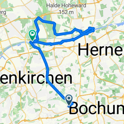
Höntrop-Kemnader See-Eisenbahnmuseum und zurück
A cycling route starting in Bochum-Hordel, North Rhine-Westphalia, Germany.
Overview
About this route
Höntrop-Eppendorf-Weitmarer Holz-Witten-Kemnader See-Burgaltendorf-Dahlhausen-S-Kurve-Blaue Brücke-Höntrop
Natürlich möglichst abseits der Strasse und auf dem Leinpfad (ist leider kartografisch nur unzureichend erfaßt, deshalb manuell angelegt)
- -:--
- Duration
- 44.1 km
- Distance
- 239 m
- Ascent
- 239 m
- Descent
- ---
- Avg. speed
- ---
- Max. altitude
Continue with Bikemap
Use, edit, or download this cycling route
You would like to ride Höntrop-Kemnader See-Eisenbahnmuseum und zurück or customize it for your own trip? Here is what you can do with this Bikemap route:
Free features
- Save this route as favorite or in collections
- Copy & plan your own version of this route
- Sync your route with Garmin or Wahoo
Premium features
Free trial for 3 days, or one-time payment. More about Bikemap Premium.
- Navigate this route on iOS & Android
- Export a GPX / KML file of this route
- Create your custom printout (try it for free)
- Download this route for offline navigation
Discover more Premium features.
Get Bikemap PremiumFrom our community
Other popular routes starting in Bochum-Hordel
 Erzbahntrasse - Zoom - Lemon Beach Club - Ewaldbahn
- Distance
- 28.7 km
- Ascent
- 86 m
- Descent
- 109 m
- Location
- Bochum-Hordel, North Rhine-Westphalia, Germany
 Eickel-GE-HE-RE-Eickel
- Distance
- 45.1 km
- Ascent
- 138 m
- Descent
- 138 m
- Location
- Bochum-Hordel, North Rhine-Westphalia, Germany
 Route zu Zeche Preußischer Zepter (1695- 1893)
- Distance
- 6.3 km
- Ascent
- 106 m
- Descent
- 73 m
- Location
- Bochum-Hordel, North Rhine-Westphalia, Germany
 ipa 2025 Herbstrunde
- Distance
- 59.9 km
- Ascent
- 227 m
- Descent
- 222 m
- Location
- Bochum-Hordel, North Rhine-Westphalia, Germany
 Nach Haltern am Kanal entlang
- Distance
- 56.4 km
- Ascent
- 220 m
- Descent
- 250 m
- Location
- Bochum-Hordel, North Rhine-Westphalia, Germany
 Herne - Herten und Umgebung
- Distance
- 29.9 km
- Ascent
- 91 m
- Descent
- 91 m
- Location
- Bochum-Hordel, North Rhine-Westphalia, Germany
 Ruhrtalradweg bei Hattingen
- Distance
- 28.8 km
- Ascent
- 243 m
- Descent
- 242 m
- Location
- Bochum-Hordel, North Rhine-Westphalia, Germany
 Rundkurs Wattenscheid-Velbert
- Distance
- 74.6 km
- Ascent
- 627 m
- Descent
- 651 m
- Location
- Bochum-Hordel, North Rhine-Westphalia, Germany
Open it in the app