

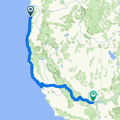
Pacific City to SLC UT
A cycling route starting in Pacific City, Oregon, United States.
Overview
About this route
- -:--
- Duration
- 1,500.1 km
- Distance
- 14,556 m
- Ascent
- 13,246 m
- Descent
- ---
- Avg. speed
- 1,733 m
- Max. altitude
Continue with Bikemap
Use, edit, or download this cycling route
You would like to ride Pacific City to SLC UT or customize it for your own trip? Here is what you can do with this Bikemap route:
Free features
- Save this route as favorite or in collections
- Copy & plan your own version of this route
- Split it into stages to create a multi-day tour
- Sync your route with Garmin or Wahoo
Premium features
Free trial for 3 days, or one-time payment. More about Bikemap Premium.
- Navigate this route on iOS & Android
- Export a GPX / KML file of this route
- Create your custom printout (try it for free)
- Download this route for offline navigation
Discover more Premium features.
Get Bikemap PremiumFrom our community
Other popular routes starting in Pacific City
 US tour day 05
- Distance
- 171.8 km
- Ascent
- 1,069 m
- Descent
- 1,000 m
- Location
- Pacific City, Oregon, United States
 Pacific City -> Tilamook
- Distance
- 39.1 km
- Ascent
- 178 m
- Descent
- 182 m
- Location
- Pacific City, Oregon, United States
 iDay 15
- Distance
- 49.3 km
- Ascent
- 389 m
- Descent
- 312 m
- Location
- Pacific City, Oregon, United States
 032c panamericana
- Distance
- 167.9 km
- Ascent
- 741 m
- Descent
- 780 m
- Location
- Pacific City, Oregon, United States
 pdx-vegas
- Distance
- 2,079.7 km
- Ascent
- 5,553 m
- Descent
- 4,952 m
- Location
- Pacific City, Oregon, United States
 CA2014 - Day 4
- Distance
- 152.7 km
- Ascent
- 728 m
- Descent
- 706 m
- Location
- Pacific City, Oregon, United States

Garmin
Pacific City Cycling- Distance
- 63.5 km
- Ascent
- 401 m
- Descent
- 513 m
- Location
- Pacific City, Oregon, United States
 Day 4
Day 4- Distance
- 99.4 km
- Ascent
- 610 m
- Descent
- 596 m
- Location
- Pacific City, Oregon, United States
Open it in the app