

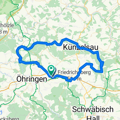
Hohenlohe mit Würth 2 und Kocher- Ohrntal und Limesblick
A cycling route starting in Neuenstein, Baden-Württemberg, Germany.
Overview
About this route
Start in Michelbach / Wald über Kesselfeld und Bahnhof Waldenburg auf der alten Kochertalbahnstrecke nach Haag / Gaisbach zum Museum Würth 2. Von dort nach Besichtigung / Einkehr über Schloß Hermersberg nach Weißbach. Entlang dem Kochertalradweg bis Ohrnberg. Von dort den Ohrntalradweg nach Öhringen und über den Limesblick zurück nach Michelbach / W.
- -:--
- Duration
- 65.2 km
- Distance
- 710 m
- Ascent
- 708 m
- Descent
- ---
- Avg. speed
- 400 m
- Max. altitude

Route quality
Waytypes & surfaces along the route
Waytypes
Quiet road
19.6 km
(30 %)
Path
17 km
(26 %)
Surfaces
Paved
57.9 km
(89 %)
Unpaved
2.1 km
(3 %)
Asphalt
53.2 km
(82 %)
Concrete
2.4 km
(4 %)
Route highlights
Points of interest along the route

Point of interest after 21.1 km
Würth Museum 2 - Aktuelle Ausstellung David Hockney

Point of interest after 60.3 km
Limesblick Öhringen
Continue with Bikemap
Use, edit, or download this cycling route
You would like to ride Hohenlohe mit Würth 2 und Kocher- Ohrntal und Limesblick or customize it for your own trip? Here is what you can do with this Bikemap route:
Free features
- Save this route as favorite or in collections
- Copy & plan your own version of this route
- Sync your route with Garmin or Wahoo
Premium features
Free trial for 3 days, or one-time payment. More about Bikemap Premium.
- Navigate this route on iOS & Android
- Export a GPX / KML file of this route
- Create your custom printout (try it for free)
- Download this route for offline navigation
Discover more Premium features.
Get Bikemap PremiumFrom our community
Other popular routes starting in Neuenstein
 Neuenstein über Kupferzell - Kochertal-bis Ohrnberg
- Distance
- 79.8 km
- Ascent
- 469 m
- Descent
- 473 m
- Location
- Neuenstein, Baden-Württemberg, Germany
 Neuenstein zum Limesblick
- Distance
- 16.7 km
- Ascent
- 114 m
- Descent
- 110 m
- Location
- Neuenstein, Baden-Württemberg, Germany
 neuenstein-schuppach-Waldenburger berge
- Distance
- 39.1 km
- Ascent
- 355 m
- Descent
- 356 m
- Location
- Neuenstein, Baden-Württemberg, Germany
 Zum Breitenauer See
- Distance
- 22.2 km
- Ascent
- 176 m
- Descent
- 247 m
- Location
- Neuenstein, Baden-Württemberg, Germany
 Neuenstein-Hirschhorn
- Distance
- 94.6 km
- Ascent
- 304 m
- Descent
- 463 m
- Location
- Neuenstein, Baden-Württemberg, Germany
 Kocher-Ohrn-Eppach Radweg
- Distance
- 75 km
- Ascent
- 310 m
- Descent
- 306 m
- Location
- Neuenstein, Baden-Württemberg, Germany
 Neuenstein
- Distance
- 17.6 km
- Ascent
- 192 m
- Descent
- 192 m
- Location
- Neuenstein, Baden-Württemberg, Germany
 Neuenstein-Kochertalroute
- Distance
- 70 km
- Ascent
- 377 m
- Descent
- 377 m
- Location
- Neuenstein, Baden-Württemberg, Germany
Open it in the app