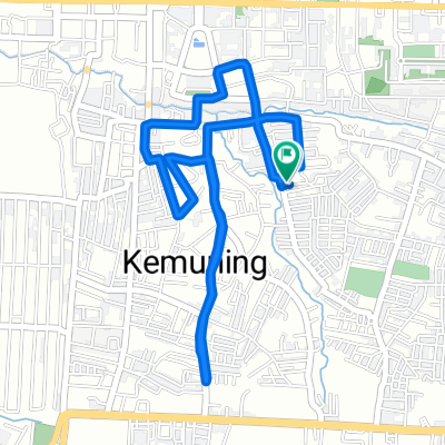
mawar opsi 1
A cycling route starting in Martapura, South Kalimantan, Indonesia.
Overview
About this route
- -:--
- Duration
- 53.7 km
- Distance
- 690 m
- Ascent
- 688 m
- Descent
- ---
- Avg. speed
- 223 m
- Avg. speed
Route quality
Waytypes & surfaces along the route
Waytypes
Busy road
28.8 km
(54 %)
Quiet road
12.7 km
(24 %)
Surfaces
Paved
12.1 km
(23 %)
Unpaved
1 km
(2 %)
Asphalt
12.1 km
(23 %)
Unpaved (undefined)
1 km
(2 %)
Undefined
40.6 km
(76 %)
Route highlights
Points of interest along the route
Point of interest after 33 km
pitstop mesjid bambu
Continue with Bikemap
Use, edit, or download this cycling route
You would like to ride mawar opsi 1 or customize it for your own trip? Here is what you can do with this Bikemap route:
Free features
- Save this route as favorite or in collections
- Copy & plan your own version of this route
- Sync your route with Garmin or Wahoo
Premium features
Free trial for 3 days, or one-time payment. More about Bikemap Premium.
- Navigate this route on iOS & Android
- Export a GPX / KML file of this route
- Create your custom printout (try it for free)
- Download this route for offline navigation
Discover more Premium features.
Get Bikemap PremiumFrom our community
Other popular routes starting in Martapura
- Jalan Kenanga 18, Kecamatan Banjarbaru Utara to Jalan Kenanga 18, Kecamatan Banjarbaru Utara
- Distance
- 12 km
- Ascent
- 39 m
- Descent
- 43 m
- Location
- Martapura, South Kalimantan, Indonesia
- Jalan Pondok Bambu 10, Kecamatan Landasan Ulin to Jalan Pondok Bambu 10, Kecamatan Landasan Ulin
- Distance
- 5.2 km
- Ascent
- 70 m
- Descent
- 90 m
- Location
- Martapura, South Kalimantan, Indonesia
- mawar opsi 2
- Distance
- 61.5 km
- Ascent
- 752 m
- Descent
- 750 m
- Location
- Martapura, South Kalimantan, Indonesia
- Jalan Melati, Kecamatan Martapura to Jalan Melati, Kecamatan Martapura
- Distance
- 16.4 km
- Ascent
- 157 m
- Descent
- 159 m
- Location
- Martapura, South Kalimantan, Indonesia
- Route from Jalan Dahlina Raya, Kecamatan Banjarbaru Selatan
- Distance
- 4.9 km
- Ascent
- 17 m
- Descent
- 74 m
- Location
- Martapura, South Kalimantan, Indonesia
- Gang Flamboyan, Kecamatan Martapura to Jalan Tanjung Rema 60, Kecamatan Martapura
- Distance
- 7 km
- Ascent
- 11 m
- Descent
- 8 m
- Location
- Martapura, South Kalimantan, Indonesia
- mawar opsi 1
- Distance
- 53.7 km
- Ascent
- 690 m
- Descent
- 688 m
- Location
- Martapura, South Kalimantan, Indonesia
- Jalan Pondok Bambu 10, Kecamatan Landasan Ulin to Jalan Sukarelawan, Kecamatan Banjarbaru Utara
- Distance
- 5.6 km
- Ascent
- 37 m
- Descent
- 24 m
- Location
- Martapura, South Kalimantan, Indonesia
Open it in the app