

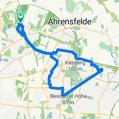
Recovered Route
A cycling route starting in Wartenberg, State of Berlin, Germany.
Overview
About this route
- 1 h 32 min
- Duration
- 15 km
- Distance
- 85 m
- Ascent
- 89 m
- Descent
- 9.8 km/h
- Avg. speed
- 65 m
- Max. altitude
Continue with Bikemap
Use, edit, or download this cycling route
You would like to ride Recovered Route or customize it for your own trip? Here is what you can do with this Bikemap route:
Free features
- Save this route as favorite or in collections
- Copy & plan your own version of this route
- Sync your route with Garmin or Wahoo
Premium features
Free trial for 3 days, or one-time payment. More about Bikemap Premium.
- Navigate this route on iOS & Android
- Export a GPX / KML file of this route
- Create your custom printout (try it for free)
- Download this route for offline navigation
Discover more Premium features.
Get Bikemap PremiumFrom our community
Other popular routes starting in Wartenberg
 Berlin HSH - Bernau - Eberswalde - Bad Freienwalde - Wriezen - Strausberg - Alt Landsberg - Bln HSH 135 Km
- Distance
- 134.6 km
- Ascent
- 303 m
- Descent
- 303 m
- Location
- Wartenberg, State of Berlin, Germany
 Kusunoki´s Berlin-Erkner-Altlandsbergtour 80 Km
- Distance
- 80.8 km
- Ascent
- 104 m
- Descent
- 106 m
- Location
- Wartenberg, State of Berlin, Germany
 Zu Kühne
- Distance
- 11.1 km
- Ascent
- 85 m
- Descent
- 98 m
- Location
- Wartenberg, State of Berlin, Germany
 Gerade Fahrt in Bernau bei Berlin
- Distance
- 57.7 km
- Ascent
- 395 m
- Descent
- 375 m
- Location
- Wartenberg, State of Berlin, Germany
 Bln HsH - Potsdam - Brandenburg a.d.H. 86,7 Km
- Distance
- 86.8 km
- Ascent
- 137 m
- Descent
- 164 m
- Location
- Wartenberg, State of Berlin, Germany
 GPS Mügelseerunde
- Distance
- 71.7 km
- Ascent
- 78 m
- Descent
- 81 m
- Location
- Wartenberg, State of Berlin, Germany
 Hagenower Ring 32, Berlin nach Hagenower Ring 34, Berlin
- Distance
- 34 km
- Ascent
- 139 m
- Descent
- 139 m
- Location
- Wartenberg, State of Berlin, Germany
 Ückeritzer Ring 31a, Berlin nach Ückeritzer Ring 31a, Berlin
- Distance
- 27.1 km
- Ascent
- 84 m
- Descent
- 87 m
- Location
- Wartenberg, State of Berlin, Germany
Open it in the app