

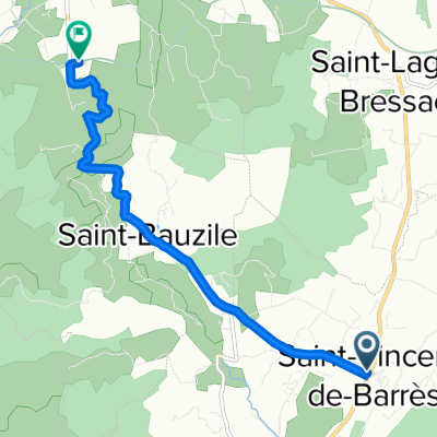
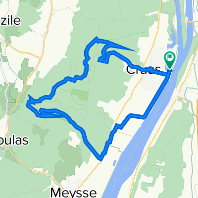
viarhona-zuid-2
A cycling route starting in Cruas, Auvergne-Rhône-Alpes, France.
Overview
About this route
- -:--
- Duration
- 23.5 km
- Distance
- 62 m
- Ascent
- 78 m
- Descent
- ---
- Avg. speed
- 122 m
- Max. altitude

Route quality
Waytypes & surfaces along the route
Waytypes
Quiet road
15.7 km
(67 %)
Road
3.3 km
(14 %)
Surfaces
Paved
13.1 km
(56 %)
Unpaved
1.6 km
(7 %)
Asphalt
13.1 km
(56 %)
Gravel
1.6 km
(7 %)
Undefined
8.7 km
(37 %)
Continue with Bikemap
Use, edit, or download this cycling route
You would like to ride viarhona-zuid-2 or customize it for your own trip? Here is what you can do with this Bikemap route:
Free features
- Save this route as favorite or in collections
- Copy & plan your own version of this route
- Sync your route with Garmin or Wahoo
Premium features
Free trial for 3 days, or one-time payment. More about Bikemap Premium.
- Navigate this route on iOS & Android
- Export a GPX / KML file of this route
- Create your custom printout (try it for free)
- Download this route for offline navigation
Discover more Premium features.
Get Bikemap PremiumFrom our community
Other popular routes starting in Cruas
 42. Montelimar - Floral Camping - Valence - Lyon
- Distance
- 139 km
- Ascent
- 507 m
- Descent
- 425 m
- Location
- Cruas, Auvergne-Rhône-Alpes, France
 etappe 12
- Distance
- 104.6 km
- Ascent
- 49 m
- Descent
- 140 m
- Location
- Cruas, Auvergne-Rhône-Alpes, France
 40 Route de St-Bauzile, Saint-Vincent-de-Barrès à Chomérac
- Distance
- 6.7 km
- Ascent
- 100 m
- Descent
- 124 m
- Location
- Cruas, Auvergne-Rhône-Alpes, France
 Rhone Tag 6
- Distance
- 26.7 km
- Ascent
- 221 m
- Descent
- 208 m
- Location
- Cruas, Auvergne-Rhône-Alpes, France
 Long bike tour through Le Grau-du-Roi
- Distance
- 180.8 km
- Ascent
- 427 m
- Descent
- 518 m
- Location
- Cruas, Auvergne-Rhône-Alpes, France
 Cruas Bike
- Distance
- 22.6 km
- Ascent
- 519 m
- Descent
- 518 m
- Location
- Cruas, Auvergne-Rhône-Alpes, France
 viarhona-zuid-2
- Distance
- 23.5 km
- Ascent
- 62 m
- Descent
- 78 m
- Location
- Cruas, Auvergne-Rhône-Alpes, France
 La Coucourde - Avignon (Camping Les Deux Rhone)
- Distance
- 106.7 km
- Ascent
- 97 m
- Descent
- 167 m
- Location
- Cruas, Auvergne-Rhône-Alpes, France
Open it in the app